Why “Light Flurries” Always Means “Surprise Snowpocalypse”
Explore why unexpected snowstorms often begin as 'light flurries' and how this misleading term leads to surprising and severe winter weather.
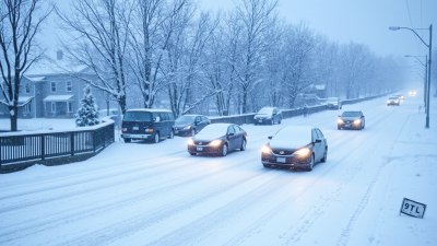
Image created with Flux Schnell
When you hear the term “light flurries,” you might imagine a gentle dusting of snow that barely coats the ground, something that’s more decorative than disruptive. However, for many, this innocuous phrase has become synonymous with a sudden and intense winter storm, an unexpected snowpocalypse that paralyzes roads, grounds flights, and sends people scrambling for last-minute supplies. But why does the phrase “light flurries” so often lead to such a surprising and severe snow event? To understand this, we must delve into meteorological language, atmospheric conditions, forecasting challenges, and human perception.
The Meteorology Behind Flurries
In weather terminology, “flurries” refer to light snowfall that is usually intermittent and does not typically result in significant accumulation. Unlike steady snow or heavy snowfall, flurries are defined by their sporadic nature and minimal impact. Meteorologists use the term to describe snow showers that are brief and scattered, often less than 0.1 inch accumulation. “Light flurries” thus indicate conditions with snow falling lightly and occasionally, generally not expected to disrupt daily life.
However, weather systems are dynamic and complex. The state of the atmosphere changes rapidly, sometimes causing what starts as light flurries to evolve into more severe snow events. Flurries often occur on the leading edge of storm systems or as remnants when a larger storm is moving out, and this can mask the true intensity of what’s to come.
Why “Light Flurries” Can Be Misleading
One key factor is the unpredictability of snowfall intensity and accumulation. The atmospheric environment can change suddenly—temperature variations, moisture influx, and wind shifts can enhance snowfall rates drastically. Despite initial flurries, conditions may rapidly worsen due to increased moisture or temperature drops that support heavier snow. So, an early forecast or sky report calling for light flurries may not capture the full development of a snowstorm that is just beginning.
Furthermore, the term itself tends to downplay potential risks. When weather services announce “light flurries,” people often assume minimal impact and thus fail to prepare adequately. This underestimation contributes to the shock when heavy snow eventually arrives, leading to the surprise element in the phrase “surprise snowpocalypse.”
The Science of Snowstorm Development
Snowstorms develop due to complex interactions between cold air masses, moisture sources, and atmospheric dynamics. Initially, an approaching cold front or low-pressure system might bring only scattered snow showers or flurries. During this stage, the conditions are marginal, and precipitation is light. However, as the system intensifies, it can pull in more moisture from bodies of water like lakes or oceans, especially when atmospheric lift enhances condensation. This process can cause rapid increases in snowfall rates.
For example, lake-effect snow occurs when cold air moves over relatively warmer lake waters, picking up moisture and heat, then releasing it as heavy snow downwind. An initial flurry warning near the lakes’ periphery can quickly escalate into a snowpocalypse as the cold front shifts and the lake atmosphere interaction strengthens. Thus, what begins as “light flurries” near a lake region can become intense, localized snow showers with significant accumulation in short order.
The Challenges of Weather Forecasting
Meteorologists rely on advanced computer models to predict snow events, but forecasting snow intensity and accumulation remains challenging. Models must factor in numerous variables: temperature profiles, humidity levels, wind patterns, terrain, and timing of frontal systems. Small inaccuracies or changes in these variables can result in drastically different outcomes. Hence, early in a storm’s lifecycle, forecasts may only confidently predict light snow or flurries, without fully capturing the system’s potential explosiveness.
These forecast updates happen frequently as new data comes in, but the communication of these changes to the public is not always uniform or timely. A morning report may mention light flurries, while the afternoon advisory upgrades to a winter storm warning hours later. The lag in updating public perception can cause confusion and underpreparedness when the snowpocalypse hits unexpectedly.
Human Perception and Weather Messaging
Language plays a critical role in how weather is perceived. Terms like “light,” “flurries,” and “snow showers” suggest mild conditions, which can lull people into a false sense of security. This semantic effect means that even when meteorologists intend to convey caution, the words used may minimize the perceived threat.
Moreover, the historical experiences of individuals shape their reactions. In regions where light flurries regularly occur with no consequence, residents may disregard such forecasts. On the other hand, in more temperate zones where snow is rare, even slight flurries can cause major disruptions. In either case, the discrepancy between the term’s mild headline and the resulting conditions fuels the narrative of a “surprise snowpocalypse.”
Social Media and Real-Time Updates
The advent of social media has altered how weather warnings reach the public. During a snow event initially described as “light flurries,” users post images and videos of sudden heavy snowfall, road closures, and traffic accidents. These real-time reports often amplify the sense of surprise and urgency. The contrast between the official forecast and the unfolding situation may contribute to widespread frustration and confusion.
Nonetheless, social media also serves as a critical tool for disseminating new updates quickly, enabling some communities to respond faster to changes in weather conditions caused by developing storms. This dynamic, however, depends on network coverage, user engagement, and trust in online information sources.
The Impact on Transportation and Infrastructure
When a light flurries forecast evolves into a full-blown snowstorm, transportation systems face sudden stress. Snow accumulation impacts road safety, public transit operations, and flight schedules. Infrastructure prepared only for minimal snowfall may become overwhelmed. This disparity between forecast and reality often results in clogged highways, accidents, and travel delays, reinforcing the surprise factor.
Road maintenance crews plan their activities based on forecasts. If initial reports indicate light flurries, they may delay plowing or salting operations. When snow intensifies unexpectedly, the subsequent response time may be insufficient to keep roads clear, exacerbating hazards and inconvenience.
The Psychological and Economic Effects
Unexpected severe snowfalls have psychological impacts, causing stress and anxiety amongst commuters, students, and workers. People may be forced to stay home, miss appointments, or delay essential errands. Distrust in weather forecasts can grow if “light flurries” warnings routinely precede difficult snow conditions.
Economically, surprise snowpocalypses disrupt commerce and supply chains. Deliveries may be delayed, employees unable to reach workplaces, and businesses forced to close temporarily. These unforeseen disturbances incur costs that accumulate regionally, especially when such events become frequent occurrences during a winter season.
Improving Communication and Forecasting Accuracy
To reduce the mismatch between “light flurries” warnings and actual snow impact, meteorologists and weather services are continuously refining their communication strategies. Providing clearer explanations of uncertainty, potential for rapid changes, and preparatory advice helps bridge the gap in understanding.
Technological advancements also contribute significantly. Improved satellite observations, radar data, and model resolutions increase the accuracy of snowfall predictions. Enhanced public alert systems can send timely updates to mobile devices, allowing people to adjust plans more responsively.
Adopting a Preparedness Mindset
For individuals living in or traveling through regions prone to winter weather, a prudent approach is to treat even “light flurries” advisories seriously. Carrying basic winter emergency supplies, checking multiple weather information sources, and allowing extra travel time can mitigate the impact of unexpected snow intensification.
Understanding that weather conditions are inherently variable helps set realistic expectations. Instead of viewing “light flurries” as a benign event, recognizing the potential for escalation fosters better personal and community preparedness, reducing surprises associated with sudden snowpocalypses.
Historical Instances of “Light Flurries” Snowpocalypses
Several notable winter storms began deceptively under the modest banner of flurries. The infamous Blizzard of 1996 in the eastern United States initially started with light snow showers, catching many off guard before dumping over two feet of snow in some areas. Similarly, the February 2019 snowstorm, which surprised parts of the Midwest, was preceded by forecasts predicting scattered light flurries or light snow.
These events emphasize the importance of close monitoring, timely updates, and public readiness in the face of evolving winter weather. They reinforce the idea that “light flurries” forecast labels should not lead to complacency.
“Light flurries” can be a misleading term that often underrepresents the potential severity of upcoming snow events. The dynamic nature of winter storms, combined with forecasting limitations and public perception, contributes to the surprise snowpocalypse phenomenon. While meteorologists strive to improve predictions and communication, individuals and communities must adopt cautious attitudes toward even seemingly mild snowfall warnings. By understanding the complexities behind the term “light flurries” and the science of snowstorm development, we can better prepare for and respond to unexpected winter weather, reducing disruption and enhancing safety during the snowy months.