How Weather Conditions Affect Satellite Imagery
Explore how varying weather conditions impact satellite imagery quality, analysis, and applications in earth observation and remote sensing.
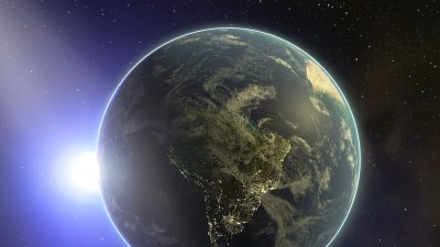
Satellite imagery plays a crucial role in monitoring Earth's surface for various applications such as environmental management, disaster response, agriculture, and urban planning. These images, captured by satellites orbiting Earth, provide invaluable data by offering a comprehensive view of large geographic areas. However, the quality and reliability of satellite imagery are heavily influenced by weather conditions. Understanding how different weather elements affect satellite images is essential for enhancing image interpretation and maximizing their use in practical scenarios.
Cloud Cover and Its Impact
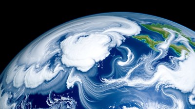
One of the most significant weather factors impacting satellite imagery is cloud cover. Clouds are composed of water droplets or ice crystals that scatter and absorb light, obstructing the satellite's view of the Earth's surface. Optical satellites that rely on visible and near-infrared light are particularly affected. Thick cloud cover can completely block the sensor’s line of sight, rendering images unusable for detailed surface analysis. Partial cloud cover can also cause shadows and irregular illumination that complicate image interpretation.
Persistent cloud cover is especially problematic in tropical regions and in certain seasons, limiting optical satellite data availability. For instance, during monsoon seasons or in equatorial rainforests, keeping track of environmental changes or agricultural conditions through optical imagery becomes challenging.
Precipitation Effects
Rain, snow, and other forms of precipitation can adversely affect satellite imagery in multiple ways. Heavy precipitation increases atmospheric moisture and particulates, which can scatter electromagnetic signals and reduce image clarity. Additionally, precipitation can cause surface conditions to change rapidly, such as flooding or snow accumulation, which may or may not be captured accurately depending on the timing and sensor type.
In optical imaging, raindrops on a sensor lens or satellite’s optical components don’t directly affect images due to the satellite’s distance from Earth, but atmospheric particles do scatter light affecting image quality. In contrast, active sensors like radar can penetrate clouds and precipitation to some extent, but heavy rain or snow can attenuate radar signals, degrading image resolution and contrast.
Fog and Haze Interferences
Fog and haze, composed of tiny water droplets or fine particulate matter suspended close to the ground, also interfere with satellite imagery. These atmospheric particles scatter sunlight, leading to diffuse reflections and reduced contrast in images. Optical sensors can struggle to differentiate between land features under heavy haze or fog conditions. This can bias land cover classification, vegetation monitoring, or urban mapping results.
While haze primarily affects the visible and near-infrared bands by reducing image sharpness, other spectral bands such as thermal infrared may be less affected. Advanced image processing techniques and atmospheric corrections are often required to mitigate these effects and recover accurate surface information.
Sun Angle and Illumination Conditions
The position of the sun relative to the Earth and satellite at the time of image acquisition influences illumination and shadowing in satellite imagery. Low sun angles, such as early morning or late afternoon images, produce long shadows that can both enhance and degrade image interpretation depending on target features. Shadows can highlight topographic relief but can also obscure details on the surface.
Weather-induced conditions like overcast skies reduce direct solar illumination and increase diffuse light, flattening the image’s appearance. This deviation may hinder identifying subtle textures or features but can reduce harsh shadows in rugged terrain.
Wind and Atmospheric Turbulence Effects
Surface winds and atmospheric turbulence do not directly distort satellite images but have indirect effects. Strong winds induce surface changes such as ocean waves, dust storms, or vegetation movement, which can appear as noise or artifacts in the imagery. For coastal and marine monitoring, wind-driven waves modify surface reflectance patterns, affecting sea state analysis.
Wind-related disturbances such as airborne dust or sandstorms increase atmospheric particles that scatter or absorb light, leading to lower image quality. Such events can last for hours to days, creating extended periods of compromised satellite visibility.
Temperature and Heat Effects
Temperature influences satellite imaging primarily in thermal infrared bands. Thermal sensors capture emitted radiation from Earth’s surface related to temperature differences. Temperature inversions, heat emissions from urban areas (urban heat islands), and temperature variations affect thermal imagery interpretation.
Temperature fluctuations can introduce noise at the sensor level due to instrument sensitivity and calibration challenges. Additionally, solar heating during the day causes changes in surface reflectance properties observed in optical imagery, which are intertwined with weather-driven temperature changes.
Atmospheric Water Vapor and Gas Composition
Water vapor is a key atmospheric constituent that absorbs specific electromagnetic wavelengths, especially in infrared bands. Variability in atmospheric water vapor affects satellite sensor readings, reducing accuracy in derived products like surface temperature or moisture content. Similarly, gases like ozone, carbon dioxide, and aerosols contribute to varying atmospheric opacity.
Weather patterns influence how much water vapor is present in the atmosphere. Humid conditions with high water vapor content generate stronger absorption bands, while arid conditions lead to clearer atmospheric windows. This variability necessitates atmospheric correction processes that adjust satellite data according to weather-influenced atmospheric composition.
Seasonal Weather Variations
Seasonal weather changes bring systematic impacts on satellite imagery. For example, snow cover in winter dramatically alters surface reflectivity, leading to very bright images in optical bands and affecting vegetation indices. Wet seasons introduce increased cloud and precipitation frequencies, reducing clear-sky image availability.
Seasonality also affects phenological changes in vegetation, which satellite sensors monitor to assess ecosystem health. However, disentangling phenological signals from weather impacts like cloud cover and precipitation remains a technical challenge.
Mitigation Techniques for Weather Impacts
Several approaches exist to mitigate the adverse effects of weather on satellite imagery. One common solution is the use of radar (Synthetic Aperture Radar, SAR) satellites that emit microwave signals capable of penetrating clouds, rain, and haze. Radar sensors enable all-weather, day-and-night imaging but have different image characteristics compared to optical sensors, requiring specialized interpretation.
Another mitigation strategy involves multi-temporal and multi-sensor data fusion. Combining optical images acquired during clear weather with radar data or thermal imagery helps build a more comprehensive and less weather-affected view.
Image processing techniques like atmospheric correction algorithms adjust data to minimize scattering and absorption effects. Cloud masking and cloud shadow detection methods identify and exclude compromised pixels from analysis. Machine learning techniques are increasingly applied to estimate missing data or predict surface conditions under cloudy skies.
Case Studies Illustrating Weather Effects
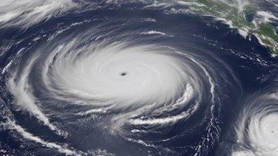
For example, during hurricane events, rapid weather changes challenge satellite imaging. Optical imagery often shows storm clouds obscuring the ground, while radar images provide crucial data about wind patterns and flood extents. Similarly, in regions prone to monsoons, imagery gaps occur due to persistent clouds, making the combination of multiple satellite systems essential.
In agricultural monitoring, cloudy and rainy weather seasons hinder crop growth assessment through optical imagery, while thermal and radar data provide alternative measures of plant health and soil moisture.
The Future of Satellite Imaging in Diverse Weather
Advancements in satellite technology aim to overcome weather constraints. Launches of constellations with higher revisit rates increase the likelihood of acquiring cloud-free images. Hyperspectral sensors improve atmospheric correction and enhance feature discrimination despite weather variability.
Integration of artificial intelligence with satellite data streams is enabling more accurate weather impact forecasting and image restoration. Furthermore, novel sensor designs and orbital trajectories are being explored to optimize data acquisition under difficult atmospheric conditions.
Ultimately, understanding and managing weather influences are pivotal in leveraging satellite imagery for environmental monitoring, resource management, disaster mitigation, and scientific research. Continued innovation in sensors, data fusion, and processing algorithms will enhance the reliability of satellite imagery regardless of the weather.