How Capping Inversions Prevent Thunderstorms From Forming
Explore how capping inversions act as atmospheric lids, blocking thunderstorm development and impacting weather patterns.
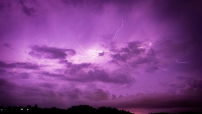
Thunderstorms are among the most dramatic manifestations of atmospheric instability, featuring towering cumulonimbus clouds, lightning, and intense rainfall. However, despite favorable conditions such as ample moisture and surface heating, thunderstorms do not always develop. One major reason for this phenomenon is the presence of a capping inversion, an atmospheric layer that effectively suppresses convection and inhibits storm formation. Understanding how capping inversions work is crucial for meteorologists aiming to forecast severe weather and for appreciating the complex dynamics governing the atmosphere.
What Is a Capping Inversion?
In the troposphere, temperature generally decreases with height, a condition known as the environmental lapse rate. This decrease encourages air parcels warmed at the surface to rise because they are less dense than the surrounding air. However, a temperature inversion occurs when a layer of air is warmer than the air beneath it, causing the temperature to increase with altitude instead of decrease. A capping inversion is a specific type of inversion that sits aloft, acting like a lid or cap on the lower atmosphere.
The cap typically forms due to subsidence warming—when air pressure compression in a high-pressure system causes air aloft to warm and suppresses convective motions. This warm layer of air, usually found between one and three kilometers above the surface, prevents the buoyant air parcels near the ground from rising beyond the inversion layer. By doing so, the capping inversion halts the vertical development of clouds needed for thunderstorms to form.
Mechanism of Thunderstorm Formation
To appreciate how a capping inversion prevents thunderstorms, it helps to review how thunderstorms develop normally. For a thunderstorm to initiate, three fundamental ingredients must be present: moisture, instability, and a lifting mechanism. Moisture provides the water vapor necessary for cloud formation. Instability arises when warm, moist air at the surface is overlain by cooler air aloft, creating a condition where air parcels can rise spontaneously. Lifting mechanisms include surface heating, terrain, or weather fronts that help push air upward.
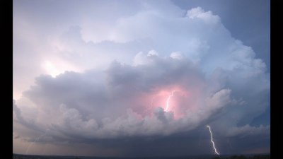
As warm, moist air rises, it cools and condenses, releasing latent heat which further fuels its ascent. This positive feedback allows the cloud to grow vertically into a towering thunderstorm. However, in the presence of a capping inversion, the parcel of rising air encounters a warmer layer above, causing it to become cooler and denser relative to the surrounding air. At this point, the rising air loses its buoyancy and descends, effectively stopping the growth of the cloud.
The Formation of the Cap
Capping inversions can form for several reasons, all related to changes in temperature and atmospheric stability. One common mechanism involves subsidence inversions associated with high-pressure systems. When air aloft sinks, it compresses and warms adiabatically, creating a warm layer that overlays cooler air at the surface. This warm air layer establishes an inversion, blocking upward airflow.
Another source can be warm advection from upper levels, where warmer air moves over a colder surface, creating a temperature inversion near the ground. At times, radiative cooling at night can cool the ground more than the air above, contributing to shallow surface inversions that affect early morning stability. However, capping inversions strong enough to suppress thunderstorms are typically found higher in the atmosphere.
The Role of Capping Inversions in Weather Prediction
Capping inversions play a critical role in weather forecasting, especially in the prediction of severe convective storms. Meteorologists monitor temperature soundings provided by radiosondes, which can reveal the presence and strength of inversion layers. A strong cap will typically appear as a sharp increase in temperature above a certain altitude, indicating a potential lid to convection.
When a strong cap is in place, forecasters often anticipate a delay or a complete suppression of thunderstorm development despite favorable surface conditions. Under these circumstances, surface heating and moisture may build up over hours without initiating convection. However, if atmospheric conditions evolve such that the cap weakens or is broken by lifting from a cold front, outflow boundary, or strong surface heating, explosive thunderstorm development may suddenly occur.
Breaking the Cap: When Thunderstorms Do Form
Although capping inversions suppress convection initially, they can paradoxically contribute to more intense thunderstorms if broken effectively. This happens because energy and moisture accumulate below the inversion while convection is suppressed, leading to strong instability. When a strong lifting mechanism forces air parcels to rise beyond the cap, the energy release is rapid and vigorous.
This can result in severe thunderstorms characterized by large hail, damaging winds, and tornadoes. Forecasters often look for signs of cap erosion or breakout to predict sudden storm initiation. For example, surface heating throughout the day might gradually reduce the strength of the inversion, or a cold front might push the cap away by bringing colder air aloft.
Geographical and Seasonal Occurrence of Capping Inversions
Capping inversions are common in certain regions and during specific times of the year. For instance, in parts of the central United States, a prominent capping inversion known as the Elevated Mixed Layer often forms when dry air from elevated plateaus moves over moist lowlands. This layer is infamous for preventing storms early in the day but enabling severe storms later when the cap breaks.
Similarly, capping inversions are more pronounced during the warmer months when strong surface heating occurs but upper-level warming due to subsidence also intensifies. Coastal regions can exhibit marine inversions where cool ocean air sits below warmer air aloft. Understanding where and when capping inversions occur assists meteorologists and climatologists in assessing severe weather potential and climate dynamics.
Impacts Beyond Thunderstorm Suppression
While capping inversions are primarily discussed in the context of convective storm suppression, they also impact air quality and temperature variations. Since the inversion layer suppresses vertical mixing, pollutants such as smog and particulate matter can become trapped near the surface, leading to degraded air quality. This phenomenon is common in urban areas during stable, capped conditions.
In addition, capping inversions can influence temperature profiles experienced at the surface. They can contribute to temperature gradients and stabilize the atmosphere, affecting local wind patterns and the dissipation of fog or low clouds. As such, capping inversions are significant in a range of meteorological and environmental contexts.
Technological Advances in Detecting Capping Inversions
Recent advances in remote sensing technology and atmospheric modeling have improved the detection and understanding of capping inversions. Weather balloons remain a primary tool to physically measure vertical temperature and moisture profiles. Satellite instruments provide additional data on temperature structures and atmospheric stability.
Numerical weather prediction models incorporate inversion data to refine forecasts of thunderstorm development. Doppler radar data and LIDAR can sometimes detect atmospheric layering indirectly by analyzing aerosol and moisture profiles. As technology progresses, forecasting the presence and behavior of capping inversions becomes more accurate, helping protect lives and property through better severe weather warnings.
Summary of Key Points
A capping inversion is a warm layer of air in the atmosphere that increases temperature with height, acting as a lid that prevents surface air parcels from rising. This cap suppresses the vertical motion necessary for thunderstorms to initiate, even if moisture and surface heating are present. Capping inversions commonly form due to subsidence warming or warm advection aloft and play a crucial role in regulating severe weather outbreaks.
While strong caps initially prevent storm development, they allow instability and energy to accumulate near the surface, which can lead to explosive thunderstorm formation if the cap breaks. These phenomena have both immediate weather impacts and influence air quality and temperature patterns. Advances in observational technology continue to enhance understanding and prediction of capping inversions and their influence on weather.