Why Air Masses Collide and Create Extreme Weather
Explore how colliding air masses trigger extreme weather events and their impact on the environment and daily life.

Air masses are large volumes of air with uniform temperature and humidity characteristics that form over specific regions called source regions. These masses can span hundreds to thousands of miles and significantly influence the weather patterns experienced across the globe. When air masses collide, the interaction often leads to the development of extreme weather conditions, including storms, heavy precipitation, and sudden temperature changes. Understanding why air masses collide and how these collisions cause extreme weather is crucial for meteorology and disaster preparedness.
What Are Air Masses?
An air mass is a vast body of air that acquires specific physical properties from its source region. The source region is typically a large, relatively uniform area with consistent surface conditions. For example, polar regions, tropical oceans, and continental interiors all serve as source regions for different types of air masses. The primary characteristics of an air mass—temperature and moisture—depend on whether it forms over land or water, and whether it originates in the tropics, mid-latitudes, or polar zones.
Scientists classify air masses using a notation system that includes a letter and sometimes a number indicating their temperature and moisture. For example, continental polar (cP) air masses are cold and dry since they originate from high-latitude land areas, while maritime tropical (mT) air masses form over warm ocean waters and are warm and moist.
How Air Masses Move and Interact
Air masses are not stationary; they move due to large-scale atmospheric circulation patterns, driven by the earth’s rotation, solar heating, and the distribution of continents and oceans. Prevailing winds in different latitudinal belts push these air masses into new areas, often causing them to collide with contrasting air masses. When two air masses with different properties meet, the boundary between them is known as a front.
There are several types of fronts—cold fronts, warm fronts, stationary fronts, and occluded fronts—each characterized by the movement of air masses relative to each other. The nature of the front and the characteristics of the colliding air masses determine the type and severity of the resulting weather.
Why Air Masses Collide
Collisions between air masses happen for a few key reasons. Firstly, large-scale atmospheric circulation patterns, such as the jet stream, drive air masses in opposite or converging directions. The jet stream is a fast-flowing river of air in the upper atmosphere that can steer air masses across continents. Areas where different air masses converge are often located along the mid-latitude storm tracks, where the most dynamic weather changes occur.
Secondly, differences in surface conditions created by geography influence air mass movement and interaction. Mountain ranges, coastlines, deserts, and ice fields can act as physical barriers or sources of thermal contrast that force air masses to change direction or elevate, inducing conflicts with other air masses.
Thirdly, seasonal changes in solar heating alter the temperature gradients across regions, changing the strength and position of air masses. During winter, cold polar air masses often push southward, encountering warm tropical air masses moving northward. This contrast intensifies the likelihood of collision and the formation of strong fronts that can trigger extreme weather events.
The Meteorology Behind Air Mass Collisions
When two air masses collide, the boundary or front between them is characterized by sharp temperature and moisture gradients. The denser, colder air mass tends to wedge beneath the warmer, lighter air mass, forcing the warm air to rise. As the warm air ascends, it cools adiabatically, causing water vapor to condense into clouds and precipitation.
This vertical motion is a key driver of various weather phenomena:
- Cloud formation and intense precipitation: The rising warm, moist air cools to form clouds and heavy rain or snow.
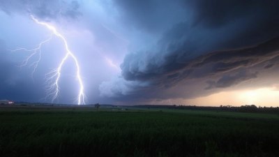
- Thunderstorms and severe weather: If atmospheric conditions are unstable, strong updrafts can develop, resulting in thunderstorm formation, hail, and tornadoes.
- Temperature contrasts and wind shifts: Sharp temperature differences along the front cause pressure changes and strong winds.
The dynamics of air mass collisions are especially significant in mid-latitude cyclones, large low-pressure weather systems that form along fronts and are responsible for much of the extreme weather in temperate zones. These cyclones intensify due to the continuous supply of contrasting air masses and can produce strong winds, heavy precipitation, and blizzards.
Types of Fronts and Their Weather Patterns
Cold Fronts occur when a cold, dense air mass moves beneath a warmer air mass, pushing it upward. This lifting generates cumulus and cumulonimbus clouds, often leading to short, intense bursts of rain or thunderstorms. Following the passage of a cold front, temperatures drop sharply, and the air becomes drier.
Warm Fronts happen when a warm air mass glides over a retreating cold air mass. The gradual ascent of warm air produces layered clouds (stratus and nimbostratus) and gentle, prolonged precipitation. Warm fronts often result in overcast skies and a gradual temperature increase.
Stationary Fronts form when neither air mass is strong enough to displace the other. This results in prolonged periods of cloudy, wet weather, often causing flooding due to days of continuous precipitation.
Occluded Fronts develop when a cold front catches up to a warm front, forcing warm air upward completely. This complex interaction frequently generates heavy rain or snow and variable wind patterns.
Extreme Weather Caused by Air Mass Collisions
The interaction of contrasting air masses is responsible for many extreme weather events worldwide, including tornadoes, hurricanes, blizzards, and derechos. Each type of event is tied to particular air mass configurations and dynamics.
Tornadoes often arise from supercell thunderstorms that develop where warm, moist maritime tropical air collides with cold, dry continental polar air in an unstable atmosphere. The vertical wind shear and strong updrafts cause rotation within the storm, leading to tornado formation.
Hurricanes form over warm tropical ocean waters and depend heavily on the supply of moist, warm air masses. While hurricanes do not result directly from colliding air masses on land, their growth relies on stable tropical air masses that provide heat and moisture fuel. Interaction with different air masses as hurricanes move toward higher latitudes can alter their strength and track.
Blizzards often occur when cold, dry polar air masses meet with warm, moist air masses, creating heavy snowfall combined with strong winds and reduced visibility. Nor’easters along the U.S. East Coast are classic examples where such air mass collisions produce severe winter storms.
Derechos are long-lived windstorms associated with fast-moving thunderstorms that often develop along cold fronts or squall lines where air masses interact vigorously, producing widespread wind damage.
Geographical and Seasonal Influences
The frequency and intensity of air mass collisions vary regionally and seasonally. Mid-latitude regions, between roughly 30 and 60 degrees latitude, are hotspots for air mass interactions due to the juxtaposition of tropical and polar air masses. Here, the jet stream provides a mechanism for their convergence.
Seasonally, the contrast between cold and warm air masses is greatest during spring and fall, leading to dynamic weather changes. However, winter brings the most intense cold air outbreaks, while summer increases the potential for severe convection and thunderstorms due to heating and moisture availability.
Human Impacts and Preparedness
Extreme weather caused by air mass collisions can have significant social, economic, and environmental impacts. Flooding from prolonged precipitation, damage from tornadoes and hurricanes, and disruptions caused by blizzards affect communities worldwide. Accurate weather forecasting hinges on understanding air mass behavior and interactions, enabling timely warnings and disaster preparedness.
Advances in meteorological science, including satellite monitoring and computer modeling, allow scientists to track air mass movements and predict their collisions with increasing accuracy. This knowledge aids governments and citizens in responding effectively to impending extreme weather.
The collision of air masses is a fundamental driver of the Earth’s variable and extreme weather phenomena. The contrasting temperature and moisture characteristics impose dynamic atmospheric interactions along fronts, precipitating a spectrum of weather events from gentle rain to destructive storms. Geography, seasonal changes, and atmospheric circulation patterns all influence where and when these collisions occur.
By studying air masses and their interactions, meteorologists uncover the mechanisms behind weather extremes, improving forecasts and helping societies mitigate risks. Awareness and preparedness remain key in adapting to the challenges posed by these powerful natural processes.