Why Not All Rain Starts as Rain in the Clouds
Explore the fascinating science behind why rain does not always begin as rain within clouds before reaching the ground.

Rain is one of the most essential elements of Earth's weather system, critical for sustaining life and shaping the environment. However, the processes that lead to rain reaching the ground are more complex than merely water droplets falling straight from clouds. In many cases, what falls as rain on the surface of the Earth may not have started as rain within the clouds themselves. This phenomenon arises due to a variety of meteorological and microphysical reasons that govern cloud formation, precipitation development, and atmospheric conditions.
Understanding why not all rain starts as rain in the clouds requires examining the lifecycle of a raindrop, the nature of clouds, and the atmospheric layers between the cloud base and the ground. It also involves the different forms precipitation can take as it falls through these layers, and how changing environmental factors can transform or initiate rainfall during its descent.
The Formation of Rain in Clouds
Precipitation begins in clouds when water vapor condenses into tiny droplets or ice crystals. Clouds form when air containing water vapor rises and cools, causing the vapor to condense around microscopic particles called cloud condensation nuclei. These droplets are usually very small, typically measuring about 10 micrometers in diameter.
Within the cloud, these droplets collide and coalesce to form larger drops in what is known as the collision-coalescence process, or by the Bergeron-Findeisen process when ice crystals are involved. These processes are crucial for generating droplets heavy enough to overcome updrafts and gravity's counteracting forces, thus beginning their descent as precipitation.
However, even at this stage, the precipitation might not yet be considered "rain." Some of the initial precipitating particles can be tiny drizzle drops, ice crystals, or snowflakes. The ultimate form the precipitation takes depends heavily on the temperature profile of the atmosphere.
The Role of Temperature Profiles in Precipitation Type
The temperature structure of the atmosphere from the cloud base to the ground profoundly influences the form precipitation assumes. If the entire column of air is cold (below freezing), precipitation will generally fall as snow or ice. Conversely, if the atmospheric column is warm, precipitation is more likely to fall as rain.
Interestingly, precipitation often changes phase multiple times as it falls, particularly in mid-latitude regions where temperature layers fluctuate with altitude. For instance, snow crystals may form at higher, cold levels within the cloud but melt into raindrops as they pass through warmer layers, or rain might freeze again if it falls through a below-freezing layer nearer to the surface, creating sleet or freezing rain.
Hence, what appears as rain on the ground may have started as snow, ice crystals, or even virga (precipitation evaporating before reaching the ground) above the cloud base.
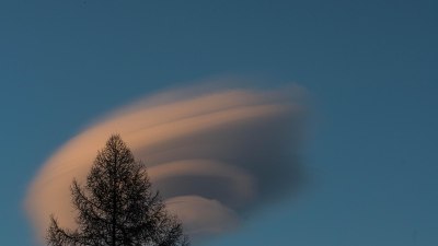
Understanding Virga: Precipitation That Never Hits the Ground
Virga refers to precipitation that forms in the clouds and begins to fall but evaporates or sublimates completely before reaching the surface. It is a common phenomenon in dry or semi-arid environments and occurs when the air beneath the cloud is dry enough to absorb the falling moisture.
When precipitation falls from a cloud into drier air below, the droplets or ice crystals can evaporate rapidly due to the difference in humidity. This process can cause the visible streaks beneath clouds that resemble rain, yet no precipitation actually arrives at ground level.
Virga illustrates why not all apparent precipitation originates as rain that reaches the surface; it may begin as rain or snow inside the cloud but never completes its journey downwards.
Rain Formation Below the Cloud Base: The Role of Evaporation and Coalescence
In some intriguing meteorological situations, what begins as rain might actually form below the cloud base. This phenomenon occurs when tiny cloud droplets or mist near or below the cloud base combine or collide during their fall, growing large enough to become rain drops before reaching the ground.
These processes depend on sufficient moisture and temperature conditions in the lower parts of the atmosphere. Sometimes, the air near the ground saturates and small droplets can agglomerate into rain-sized drops without significant precipitation having formed higher aloft.
Additionally, the evaporation of hydrometeors (precipitation particles) falling from the cloud can lead to local cooling, increasing humidity and enabling further condensation or coalescence just beneath the cloud base. This feedback can aid in rainfall initiation outside the main cloud volume.
The Impact of Atmospheric Instability and Turbulence
Atmospheric instability and turbulence can also influence whether rain starts as rain in the cloud or not. Turbulent eddies mix air vertically within the cloud and just below it, affecting droplet size distributions and the collision-coalescence efficiency needed to produce raindrops.
In unstable atmospheres with strong vertical air motions, cloud droplets may stay suspended longer, allowing additional growth or even supersaturation that leads to rapid precipitation formation. However, turbulence near the cloud base or below can also disperse droplets and influence evaporation rates, potentially delaying or preventing measurable rainfall.
This complexity means that rain may either originate deep inside clouds or develop during or just below the cloud base depending on turbulence intensity and moisture distribution.
The Role of Aerosols and Cloud Seeding
Aerosols, tiny particles suspended in the air, profoundly affect precipitation characteristics. They serve as cloud condensation or ice nuclei but can also inhibit or enhance rainfall under different circumstances.
High aerosol concentrations can lead to numerous smaller cloud droplets, which may delay the onset of rain because coalescence into larger drops is less efficient. In such cases, clouds hold more water and may produce virga or snowfall rather than direct rainfall.
Cloud seeding, an intentional human intervention, introduces additional ice or condensation nuclei to modify precipitation patterns. Sometimes cloud seeding leads to precipitation that originates deeper or differently within the cloud than it normally would, illustrating variability in rain formation locations and processes.
Environmental Conditions That Influence Rain Initiation
Several environmental factors influence where and how rain starts. These include humidity profiles, temperature gradients, wind shear, and surface-based processes.
Dry air layers below clouds increase evaporation potential, often transforming rain that starts in the cloud into virga or dry precipitation. Warm air masses can melt snowflakes formed aloft, producing rain below the cloud base. Conversely, cold surface temperatures might freeze falling rain, altering the precipitation type.
Wind shear can tilt or displace cloud structures, modifying where condensation and droplet growth occur. Surface-based processes, such as evaporation from bodies of water or vegetation transpiration, influence moisture availability and local humidity, which in turn impact precipitation formation.
Microphysical Processes Affecting Raindrop Development
At the microscopic level, raindrop formation involves complex interactions of condensation, collision, coalescence, and breakup processes. Not all cloud droplets successfully grow into rain drops that reach the surface. Many droplets remain suspended, evaporate, or are recycled within the cloud.
Temperature-dependent phase changes, such as freezing and melting, also alter drop growth paths. For example, ice crystals can grow rapidly by vapor deposition in cold clouds, but may melt into rain below. In contrast, supercooled water droplets can freeze upon contact with ice nuclei, changing drop dynamics.
These microphysical variations contribute significantly to whether precipitation initiates inside the cloud or farther down in the lower atmosphere.
Examples From Different Climates and Weather Systems
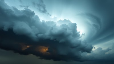
The path precipitation takes from cloud formation to the surface varies globally. In tropical climates with warm, moist air columns, rain usually begins within the cloud as large droplets that fall directly to the ground. Convective storms build tall cumulonimbus clouds where raindrops develop rapidly.
In contrast, in arid or semi-arid regions, precipitation may frequently evaporate before reaching the surface, appearing as virga. Midlatitude winter storms often feature layered temperature profiles that cause snow, sleet, freezing rain, or rain to develop in sequence, demonstrating multiple changes in precipitation phase after cloud exit.
Orographic precipitation caused by air rising over mountains can also show complex vertical profiles, where rain sometimes forms just below or even partially outside the main cloud layer due to local humidity and temperature patterns.
The Influence of Cloud Types on Rain Formation
The type of cloud impacts rain formation locations and mechanisms. For example, stratiform clouds, being relatively thin and layered, produce gentle rain that mostly begins as drizzle or small droplets within the cloud, often coalescing further on the way down.
Convective clouds, however, are vertically developed and support vigorous droplet growth and ice processes, often forming rain well within the cloud. Cirrus clouds, made up of ice crystals high in the atmosphere, rarely yield rain that reaches the surface directly; their ice crystals typically sublimate before descending low enough.
Cumulus congestus clouds can produce varying types of precipitation depending on their vertical extent, sometimes generating rain that originates below the main cloud mass.
Why Understanding Rain Formation is Important
Appreciating the nuances of where rain starts has practical implications for weather forecasting, agriculture, water resource management, and climate studies. Accurate prediction of rainfall intensity and type depends on knowing cloud microphysics and atmospheric profiles.
For farmers, understanding if precipitation will arrive as rain, snow, or virga affects planting and harvesting decisions. Water managers rely on precipitation data that consider how much reaches the surface. Climate models require detailed representation of cloud and precipitation processes to project future weather patterns reliably.
Summary of Key Factors Explaining Rain Formation Variability
Several key factors explain why rain does not always start as rain inside the clouds:
- Temperature profiles dictate precipitation phase changes between cloud base and ground.
- Atmospheric dryness below clouds can cause evaporation of precipitation (virga).
- Rain can form or grow below cloud base through coalescence processes.
- Turbulence and instability affect droplet growth and precipitation efficiency.
- Aerosol concentrations modify droplet size and rain initiation.
- Microphysical processes influence droplet formation, melting, freezing, and evaporation.
- Cloud type and vertical structure govern precipitation development height.
- Environmental variables like humidity and wind shear modulate rainfall formation.
Altogether, these factors create a dynamic system that results in diverse scenarios where not all rain starts directly as rain within the clouds. Instead, the precipitation journey is often complex, involving phase changes, evaporation, and secondary formation in the atmosphere.
Through continued research and detailed weather observations, meteorologists deepen our understanding of these processes, enabling better forecasting and an enriched appreciation of Earth's intricate weather phenomenon.