What the Jet Stream Looks Like From Space
Discover the stunning appearance of jet streams from space and their impact on Earth's weather and climate patterns.
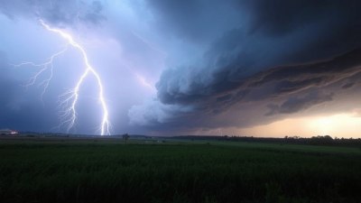
The jet stream is an incredible atmospheric phenomenon that plays a crucial role in shaping weather patterns across the globe. When viewed from space, the jet stream appears as a narrow, fast-flowing air current high in the atmosphere, often visualized as sinuous bands stretching thousands of miles around the Earth. Satellites equipped with advanced imaging technologies have provided vivid, dynamic views of these powerful streams, revealing their structure, movement, and interactions with weather systems.
Located near the tropopause, approximately 8 to 15 kilometers above the Earth's surface, jet streams are concentrated ribbons of wind that can reach speeds exceeding 250 miles per hour. Their position and intensity vary with the seasons, typically forming near boundaries between air masses with contrasting temperatures. The primary jet streams in each hemisphere, the polar jet and subtropical jet, encircle the planet and influence everything from storm tracks to temperature distributions.
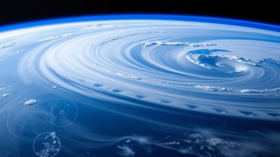
From orbiting platforms such as weather satellites and the International Space Station, the jet stream is not directly visible to the naked eye because it consists of moving air. Instead, cameras capture indirect evidence of its presence by imaging cloud formations and water vapor patterns that align with the jet's path. Infrared sensors detect temperature contrasts, and moisture-sensitive instruments map the distribution of atmospheric water vapor, which often concentrates along the jet stream’s boundaries. These images show winding, ribbon-like structures with sharp gradients in temperature and humidity, illustrating the dynamic and evolving nature of these upper atmospheric currents.
One of the most striking aspects of the jet stream's appearance from space is how it meanders in a wave-like pattern around the Earth. This waviness, known as Rossby waves, affects weather by modulating the movement of air masses and storm systems. The peaks and troughs of these waves can be expansive, spanning thousands of kilometers, and their shape greatly influences whether a region experiences cold snaps, heatwaves, or prolonged precipitation. Satellite time-lapse sequences elegantly display these changes, making clear how the jet stream acts as a conveyor belt for weather phenomena.
Advanced visualization techniques have allowed meteorologists and scientists to create detailed maps of the jet stream’s altitude, speed, and direction in near real-time. Combining data from multiple satellites with atmospheric models, researchers generate three-dimensional representations that highlight the complex interplay between the jet stream and other atmospheric layers. These visualizations are crucial for improving long-term weather forecasting and understanding climate variability, as shifts in jet stream patterns often precede significant weather events.
The jet stream has a profound effect on aviation as well. Aircraft frequently utilize jet streams for tailwinds to decrease travel time and fuel consumption, especially on transcontinental and transoceanic flights. Pilots and flight planners access data derived from satellite observations of the jet stream to determine optimal routes. When viewed through thermal or water vapor imagery from space, these flight corridors closely correspond with the unusually fast-moving segments of the jet stream.
Climate change is also altering the behavior of jet streams, a change that can be detected in satellite observations. As global temperatures rise, the temperature gradient between polar and tropical air masses shifts, potentially weakening or shifting the jet stream’s position. This can result in more persistent weather extremes, including long-lasting droughts or floods. Satellite data collected over decades is instrumental in detecting these trends and helping researchers understand future climate scenarios.
Photographs and composite images captured from various space missions have been instrumental in educating the public about the jet stream. Earth imagery platforms, like NASA’s Earth Observatory and NOAA’s satellite programs, regularly publish striking visuals that show jet streams swirling above cloud formations. These images depict the jet stream as bands of white clouds, highlighting the high-altitude cirrus and other cloud types formed by turbulent air currents. The contrast against the deep blue of Earth's atmosphere and surface features like oceans and continents creates a visually stunning scene.
The study of jet streams from a space-based perspective has also enhanced our understanding of their interactions with other geophysical phenomena. For example, the jet stream can modulate the formation and progression of tropical cyclones and influence the spread of aerosols and pollutants in the upper atmosphere. By monitoring these interactions via satellite data, scientists can better predict environmental impacts and develop more accurate environmental policies.
In summary, the jet stream, though invisible as pure air currents, reveals its presence through intricate cloud patterns and atmospheric signatures when viewed from space. Satellite imagery offers a unique vantage point to appreciate the vast scale and complexity of these powerful wind streams, showcasing their undulating paths around the globe. Understanding what the jet stream looks like from space not only satisfies curiosity but also provides critical information that benefits meteorology, climate science, and aviation, underscoring the profound interconnectedness of Earth’s atmospheric systems.
Continued advancements in satellite technology promise even more refined and dynamic visualizations of jet streams in the years ahead. Hyperspectral imaging, radar-based wind measurement, and global observation networks will enhance our capability to monitor these high-altitude winds in unprecedented detail. As this science evolves, so too will our understanding of how jet streams impact daily weather, long-term climate trends, and the planet’s overall atmospheric balance.
Ultimately, observing the jet stream from space reminds us of the complexity and beauty inherent in Earth's atmosphere. These swift, invisible rivers of air are vital components of the natural forces that shape our climate and weather, and their majestic, sinuous forms as captured from orbit inspire ongoing exploration and appreciation of our dynamic planet.