What Causes Some Storm Clouds to Anvil Out
Explore the science behind storm clouds and why some develop anvil shapes, affecting weather patterns and precipitation.
Storm clouds, often a foreboding sight, are fascinating structures in the atmosphere. They not only indicate impending weather changes but also possess unique characteristics that can vary dramatically from one storm to another. Among these characteristics is the phenomenon known as ‘anviling out.’ But what causes some storm clouds to take on that distinct anvil shape? To answer this question, we need to delve into the fundamentals of cloud formation and the dynamics involved in storm development.
To begin with, storm clouds primarily originate from the convective process, which occurs when warm air rises into the atmosphere. When this warm air ascends, it cools and condenses into water vapor, forming clouds. In particular, convection currents within the atmosphere can lead to the development of cumulonimbus clouds, the towering giants associated with thunderstorms. But not all cumulonimbus clouds will anvil out; the conditions for this occurrence must be met.
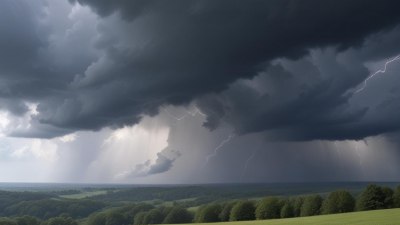
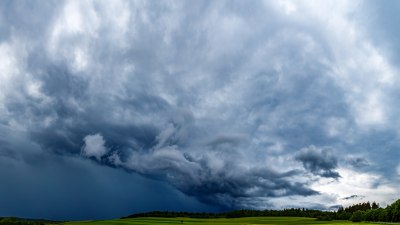
One critical factor influencing whether a storm cloud will anvil out is the stability of the atmosphere. An anvil shape is typically associated with a mature thunderstorm, where the updrafts are strong enough to carry moisture high into the troposphere, often reaching the stratosphere. When the air at high altitudes is relatively stable, the rising air cannot continue to ascend easily. This creates conditions where the cloud tops spread out laterally, resulting in the characteristic anvil shape.
Another important aspect of this phenomenon is wind shear, which refers to the change in wind speed and direction with altitude. If there is significant wind shear during a storm, the upper-level winds can transport the moisture away from the top of the cloud, enhancing the anviling effect. In essence, the strong upper-level winds can cause the cloud to spread out and flatten, contrasting the towering structure of the cloud below.
The temperature variation with altitude plays a crucial role in whether a cloud will form an anvil shape. For a cloud to anvil out, it must be capable of reaching temperatures where water vapor can transition into ice crystals. Once the rising moisture reaches colder regions at higher altitudes, it condenses, forming ice particles that are the primary components of anvil clouds. This ice formation contributes significantly to the cloud's structure and appearance.
The Role of Updrafts and Downdrafts
The vertical movement of air within a storm cloud—specifically updrafts and downdrafts—is another determinant of cloud morphology. Strong updrafts are essential for sustaining the storm. In a healthy thunderstorm, moist air rises rapidly. As it ascends, it cools, condensing to form cloud droplets. When these updrafts weaken, the air can no longer support the moisture, leading to precipitation that falls as rain. However, if the updraft persists and is vigorous enough, it can push the cloud mass higher until it encounters stable layers of air that cause it to flatten and spread out.
In cases where downdrafts are prevalent, particularly in thunderstorms undergoing a lifecycle of precipitation, this can suppress the development of an anvil. Downdrafts result from cool air sinking to the surface, replacing the warm air that had risen. In doing so, these can hinder the overall growth of the storm, reducing the likelihood of it developing an anvil top.
The surrounding atmospheric environment greatly influences the behavior and structure of storm clouds. For instance, when these clouds encounter mountains or other geographical features, the resultant uplift can enhance the storm cloud's development. The interaction between geography and meteorological conditions highlights the complexity of storm formation. Additionally, nearby weather systems can also affect the outcome, leading to varied storm characteristics.
Temperature inversions, which occur when a layer of warmer air traps cooler air at the surface, can also contribute to the development of anvil-shaped clouds. These inversions can restrain vertical development, causing storm clouds to spread out as they reach the inversion layer. In such scenarios, the anviling feature can become even more pronounced as the airflow can be disrupted and redirected by the inversion.
The type of cloud also influences whether it will anvil out. Cumulonimbus clouds are specifically known for forming thunderstorm systems and having more potential to develop anvil tops due to their vertical growth. In contrast, other cloud types, such as stratus or stratocumulus, lack the necessary dynamics for anviling, as they are more stratified and lack significant vertical development.
Understanding the life cycle of a thunderstorm is crucial for grasping why some storms anvil out while others do not. The life cycle is typically divided into three stages: the cumulus stage, the mature stage, and the dissipating stage. During the cumulus stage, moist air rises, forms a cumulus cloud, and may not yet exhibit an anvil shape. It is in the mature stage that thunderstorms often exhibit the most dramatic features including anvil clouds. As the storm matures, strong updrafts and downdrafts interact, producing precipitation. If conditions are favorable, the storm may continue to grow and extend upwards to form an anvil.
Anvil clouds are not merely for show; they play a significant role in weather and climate systems. The presence of an anvil can affect local weather patterns, influencing rainfall amounts and distribution. Furthermore, they play a role in the Earth’s radiation balance, as high clouds can reflect sunlight back into space while also trapping some of the outgoing infrared radiation, thus impacting temperature regulation on a global scale.
In summary, the phenomenon of storm clouds anvil out involves a complex interplay of atmospheric dynamics, including updraft strength, atmospheric stability, wind shear, temperature variations, and interactions with the environment. Each factor contributes to the unique and tumultuous beauty of storm clouds. Understanding why some clouds assume the anvil shape deepens our appreciation of the aesthetic magnificence while also highlighting the intricate balance of our atmosphere. So next time a storm rolls in, you might take a moment to look at those anvil shapes up high and think about the meteorological wonders that led to their formation.