What a Low Pressure System Looks Like From Space
Explore the striking appearance and features of low pressure systems as seen from space, revealing their role in Earth's weather dynamics.

Observing the Earth's weather from space offers a breathtaking and insightful perspective of atmospheric phenomena. One such phenomenon is the low pressure system, which plays a crucial role in shaping weather patterns across the globe. When viewed from satellites orbiting high above the Earth, these systems present distinctive visual characteristics, enabling meteorologists and scientists to track their development, movement, and potential impact on the surface below.
Low pressure systems, often associated with storms, precipitation, and unsettled weather, manifest in the atmosphere due to a drop in atmospheric pressure. This causes surrounding air to flow inward towards the center of low pressure, rising and often condensing into clouds and precipitation. From space, the swirling motion of this inward air flow can be vividly observed, especially in the mid-latitudes where these systems dominate weather changes.
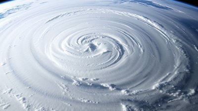
Typically, a low pressure system appearing from a satellite's vantage point exhibits a cyclonic rotation, which manifests as a spiral pattern of clouds. This spiral can sometimes be tight and compact or broad and diffuse, depending on the intensity and stage of the system. Satellites capturing visible and infrared imagery often reveal the intricate cloud bands wrapping counterclockwise in the Northern Hemisphere and clockwise in the Southern Hemisphere, a direct result of the Coriolis effect influencing airflow.
The center of a low pressure system generally appears as a region with comparatively fewer clouds called the eye or the low pressure center, though this feature is more prominent in strong cyclones like hurricanes. For weaker lows or typical mid-latitude depressions, the cloud cover may be more continuous, yet there is still a noticeable circular organization of weather fronts and cloud bands. These cloud formations provide meteorologists with valuable clues regarding the strength, structure, and movement of the system.
Visual details captured by geostationary and polar-orbiting weather satellites highlight various cloud types within the system. Thick cumulonimbus clouds often cluster near the center or along frontal boundaries, creating intense thunderstorms. In contrast, stratiform clouds appear in more widespread regions, producing steady precipitation over large areas. Altitude differences in cloud tops reflect temperature variations detected through infrared imaging, assisting in assessing storm development and potential severity.
Commonly, low pressure systems exhibit extended cloud bands that correspond to warm and cold fronts. Warm fronts feature layered, widespread clouds that gently precede warmer air masses, while cold fronts showcase sharper, towering clouds indicating more abrupt and intense weather changes. These cloud bands stretch outward, enhancing the spiral effect and making the system's circulation apparent even without ground-level observations.
Satellite observations also reveal related atmospheric features such as mesoscale convective systems, squall lines, and embedded vortices within the low pressure area. These smaller-scale elements contribute to the overall weather experienced on the surface, influencing rainfall intensity, wind gusts, and localized storm activity. By tracking these from space, forecasting accuracy improves significantly, benefiting society through timely warnings and preparedness.
In polar regions and during the winter months, low pressure systems can look notably different due to interactions with cold air masses and the presence of snow and ice clouds. Satellite imagery under these conditions depicts more diffuse cloud patterns, often highlighted by bright white snow cover on the ground and cold, high clouds above. This helps distinguish winter storms from their warmer season counterparts.
The color-enhanced images produced by modern satellites assign various shades to specific cloud temperatures, moisture levels, and precipitation presence, offering a more detailed examination of the system's characteristics. These enhancements transform otherwise monochrome images into vivid depictions where cloud tops, rain bands, and dry air intrusions can be easily identified.
Beyond visible imagery, radar data transmitted from space-based platforms contributes additional information on precipitation intensity and movement within the low pressure system. This combination of radar with satellite visual data paints a comprehensive picture for weather analysts and forecasters around the world.
Low pressure systems are instrumental in redistributing heat and moisture globally, acting as natural engines that regulate the planet's climate. Viewing their structure and behavior from space not only facilitates weather prediction but also enhances understanding of atmospheric dynamics on a planetary scale. These systems often mark the boundary between different air masses, influencing wind patterns and precipitation over vast regions.
The study of low pressure systems using satellite imagery has evolved extensively since the launch of the first weather satellites in the 1960s. Early black-and-white images provided groundbreaking views of cloud cover and storm organization, while today's high-resolution, multispectral satellites offer real-time, detailed insights into complex atmospheric processes. Instruments onboard such satellites include imagers that capture visible, infrared, and microwave data, allowing observation both in daylight and nighttime conditions.
Modern satellite platforms such as NOAA's GOES series and the European Meteosat provide continuous monitoring covering large geographical areas. This persistent observation capability ensures that low pressure systems can be tracked seamlessly through their development, movement, and eventual dissipation or transformation into other weather features.
When a low pressure system intensifies, it can develop into a tropical cyclone or hurricane, creating a well-defined eye visible from space. This eye is a calm center surrounded by a towering ring of thunderstorms known as the eyewall, which contains the strongest winds and rain. The contrast between the clear eye and the intense surrounding clouds exemplifies the dynamic nature of such systems and can be observed in vivid detail using high-resolution satellite imagery.
While not all low pressure systems evolve into hurricanes, their presence signals atmospheric instability and often precedes significant weather events such as heavy rain, thunderstorms, and frontal passages. As they move, they affect aviation, maritime activity, agriculture, and daily life, making their satellite-based observation critical for risk management and decision-making.
One illustrative example of a low pressure system from space is the classic mid-latitude cyclone seen over the North Atlantic Ocean. Such cyclones display a well-organized comma-shaped cloud pattern, with a distinct cold front trailing from the low center and a warm front extending in the opposite direction. This formation is characteristic of baroclinic systems where contrasting air masses interact intensely, generating various weather phenomena including rain, snow, and strong winds.
In addition to planet-wide applications, satellite images of low pressure systems contribute to regional studies aimed at understanding localized weather impacts. For instance, in mountainous regions, low pressure systems can induce orographic lift, enhancing precipitation on windward slopes—a feature observable through persistent cloud buildup in satellite photos. Coastal areas monitor low pressure development to anticipate storm surges and floods.
Visual observations from space also allow researchers to investigate the environmental effects of low pressure systems beyond meteorology. These systems transport aerosols, pollutants, and moisture across continents and oceans, influencing air quality and ecological processes. Satellite data integrated with models provides insights into such complex interactions.
Advancements in satellite technology continue to improve the resolution, frequency, and types of data available for analyzing low pressure systems. New generations of satellites equipped with advanced sensors detect polarization, lightning activity, and atmospheric composition, enriching the understanding of storm development influences. This enhanced capability strengthens predictive modeling, enabling better response to severe weather threats.
In summary, viewing a low pressure system from space reveals a dynamic, swirling complex of clouds and weather fronts that represent fundamental forces shaping Earth’s climate and daily weather. The characteristic spiral pattern, variable cloud structures, and associated precipitation seen from satellite imagery provide a multi-dimensional portrait of these systems. Satellite data forms the backbone of modern meteorology, facilitating real-time tracking and in-depth study of low pressure systems worldwide.
As technology progresses, the visual and analytical understanding of low pressure systems continues to deepen. Future satellite missions aimed at higher spatial and temporal resolution will offer even more detailed portraits of these ever-present atmospheric drivers, painting clearer pictures of their evolution, intensity, and influence on environments from local to global scales.
For anyone fascinated by weather, the stunning views of low pressure systems captured from space underscore the intricate yet beautiful interactions within Earth’s atmosphere. They tell a compelling story of nature’s constant motion, energy exchange, and the delicate balance that sustains life through climate regulation and water cycling.
In the end, the image of a low pressure system from space is more than just a photograph; it is a window into the dynamic heartbeat of our planet’s weather engine, observed from a vantage point only available through advanced space-based technology.


