How Warm Fronts Bring Different Clouds Than Cold Fronts
Explore how warm fronts create distinct cloud patterns compared to cold fronts through atmospheric processes and weather changes.

Image created with Flux Schnell
Weather fronts are essential features in meteorology, representing the boundaries between air masses of different temperatures. Two of the most common types of fronts are warm fronts and cold fronts. Both play significant roles in shaping our weather, and they each bring distinct kinds of cloud formations. Understanding why warm fronts produce different clouds than cold fronts involves delving into atmospheric dynamics, moisture content, and the interaction of air masses.
Defining Warm Fronts and Cold Fronts
A warm front occurs when a warm air mass advances and moves over a retreating colder air mass. Because warm air is less dense, it tends to glide up and over the cold air, leading to gradual lifting over a large area. In contrast, a cold front happens when a colder, denser air mass pushes underneath a warmer air mass, forcing the warm air to rise more rapidly and steeply.
This fundamental difference in how air masses interact explains much of the variation in cloud types and weather that develops with each front. Warm fronts generally lead to extended periods of cloudiness and light rain, while cold fronts tend to produce short-lived but often intense weather, including thunderstorms and heavy rain.
The Formation of Clouds with Warm Fronts
When a warm front advances, warm moist air is slowly lifted over the cold air wedge ahead of it. This gradual ascent causes the air to cool adiabatically, meaning it cools due to expansion in lower pressure at higher altitudes rather than losing heat directly. As the air cools, its capacity to hold water vapor decreases, leading to condensation and cloud formation.
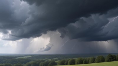
Because the lifting is gentle over an extensive region, the cloud layers tend to develop sequentially at increasing heights. The typical cloud sequence associated with a warm front starts with high-level cirrus clouds, then progresses to cirrostratus, and eventually to widespread altostratus and nimbostratus clouds as the front approaches. Nimbostratus clouds bring continuous, steady precipitation ahead of the surface front line.
The stratiform clouds in warm fronts are characterized by their layered structure and relatively uniform appearance. These clouds don't usually produce heavy rain but rather drizzle or prolonged steady precipitation. Visibility often becomes poor due to the extended cloud deck and moisture in the lower atmosphere.
Cloud Development in Cold Fronts
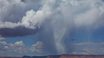
Cold fronts involve the more forceful lifting of warm air because the advancing cold air wedges aggressively beneath the less dense warm air. This rapid uplift causes faster cooling and condensation. The steep frontal slope forces warm, moist air to rise abruptly, leading to the development of cumulus and cumulonimbus clouds.
Cumulus clouds typically appear as puffy, heaped clouds indicating developing convection. When the atmosphere is unstable, these clouds can grow vertically into towering cumulonimbus clouds, which produce thunderstorms, heavy rain, hail, and sometimes tornadoes. The intense upward motion of air and latent heat release during condensation fuel these towering clouds.
Unlike the layered clouds of warm fronts, clouds along cold fronts are more convective and vertically developed. The weather changes are usually more sudden and short-lived, with sharp drops in temperature and gusty winds as the front passes. Cold fronts often produce clear air and good visibility after they move through, due to the subsiding air mass replacing the unstable warm air.
Why Cloud Types Differ Between Fronts
The key driver for the difference in cloud types is the slope of the frontal boundary and how the air masses interact. Warm fronts have a shallow slope, sometimes ranging from 1:200 to 1:500, meaning the warm air gently ascends over a broad area. This gradual lift favors the development of stratiform clouds, which spread horizontally in sheets.
In contrast, cold fronts have much steeper slopes, around 1:50, forcing rapid vertical motion. This quick ascent triggers turbulent airflow, strong updrafts, and efficient cloud growth into cumuliform shapes. The resulting clouds are more localized but demonstrate intense weather conditions.
Additionally, the stability of the air mass ahead of the front plays a crucial role. Warm fronts usually encounter stable or conditionally stable air, promoting stratiform cloud formation. Cold fronts often push into unstable air masses, encouraging deep convection and cumuliform clouds.
The Role of Moisture Content and Temperature Differences
Moisture content within the air masses also influences cloud formation. Warm air ahead of fronts tends to hold a higher amount of water vapor because warmer air can retain more moisture. As it rises and cools, this moisture condenses into clouds. In warm fronts, the moisture is gradually lifted and condensed, resulting in extended cloud decks composed mainly of water droplets.
In cold fronts, the warm air lifted tends to be very moist and unstable. This leads to rapid condensation and cloud formation with potentially vigorous precipitation. The water droplets in cumulonimbus clouds can be large and mixed with ice crystals at higher altitudes, contributing to thunderstorm activity.
The greater temperature contrast across cold fronts also intensifies updrafts and cloud growth. Warm fronts usually have less pronounced temperature differences, causing gentler uplift and less dramatic cloud development.
Typical Weather Patterns Associated with Each Front
Warm fronts generally bring gradual changes in the weather. As the clouds thicken and lower, there may be mist or fog, steady drizzle, and mild temperature increases once the warm air overtakes the cold. Winds often shift direction slowly, and the atmospheric pressure steadily falls ahead of the front.
Once the warm front passes, the weather usually becomes warmer and more humid, often with broken cloud cover.
Cold fronts, by contrast, cause rapid weather changes. Ahead of the front, the sky is often clear or cumulus clouded, but as the front approaches, increasing cumulus and cumulonimbus clouds mark the arrival of intense showers or thunderstorms. Winds typically increase in speed and change direction sharply around the frontal boundary.
After the cold front passes, cooler, drier air settles in, pressure rises, and the sky clears. These abrupt changes in weather are characteristic of cold fronts.
Visual Identification of Clouds to Recognize Fronts
Meteorologists and weather enthusiasts use cloud observation to identify approaching fronts. For warm fronts, look for progressively lower and thicker layers of clouds beginning with thin cirrus high up, followed by cirrostratus and altostratus, culminating in widespread nimbostratus. This vertical progression over hours signals a warm front is near.
For cold fronts, cumulus clouds are seen rapidly growing into large cumulonimbus towers, often producing beams of cloud and heavy rain or thunderstorms. The frontal passage is often marked by a sudden shift from clear skies to stormy weather.
Knowing which clouds correspond to warm or cold fronts helps in predicting upcoming weather without advanced instrumentation.
Examples and Case Studies
One classic example of a warm front is the advance of tropical maritime air over cooler continental air during spring in the mid-latitudes. Extensive nimbostratus clouds spreading for hundreds of kilometers bring days of light rain and overcast conditions. This was observed during many northeast US storms that develop as low-pressure systems move eastward.
Conversely, the cold front associated with a fast-moving continental arctic air mass pushing southward results in cumulonimbus clouds with severe thunderstorms. A typical case occurred during a cold front-driven severe weather outbreak in the central US, where temperatures plunged rapidly following intense storms.
The Influence of Fronts on Aviation and Daily Life
The differences in cloud types and weather associated with warm and cold fronts significantly impact aviation, agriculture, and daily activities. For pilots, warm front clouds can cause reduced visibility and continuous precipitation, requiring careful planning for instrument flight rules (IFR). Cold fronts pose risks with sudden thunderstorms, turbulence, and wind shear.
Farmers monitor fronts to plan irrigation and harvesting since prolonged drizzle from warm fronts differs in impact from brief intense rains of cold fronts. Understanding these patterns helps in mitigating risks and optimizing routines.
Advanced Meteorological Tools to Analyze Front-related Clouds
Modern weather radar, satellite imagery, and weather balloons provide detailed data on front structure and cloud characteristics. Satellites capture the layered clouds of warm fronts and the convective towers of cold fronts, while Doppler radar identifies precipitation intensity and motion, revealing frontal boundaries clearly.
Numerical weather prediction models incorporate these data to forecast frontal cloud development, improving accuracy for weather warnings and planning.
In brief, warm fronts bring gradually forming, layered stratiform clouds such as cirrus, cirrostratus, altostratus, and nimbostratus, with steady precipitation. Cold fronts cause rapid uplift producing cumuliform clouds like cumulus and cumulonimbus, leading to brief but heavy precipitation and storms.
The slope of the front, speed of lifting, atmospheric stability, moisture content, and temperature differences are principal factors influencing these cloud distinctions.
By recognizing these cloud types and their frontal origins, weather prediction becomes more intuitive and insightful.