How Upper-Level Winds Shape Severe Weather
Explore how upper-level winds influence the development and severity of severe weather events.
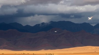
Severe weather events such as thunderstorms, tornadoes, and hurricanes are dramatic demonstrations of nature's power. While much attention is often placed on surface conditions like temperature and humidity, the role of upper-level winds in shaping these phenomena is equally critical. Understanding upper-level wind patterns allows meteorologists to better predict severe weather and helps communities prepare for potential hazards.
Understanding Upper-Level Winds
Upper-level winds refer to the prevailing wind patterns that occur in the mid to upper layers of the troposphere, typically above 10,000 feet (approximately 3,000 meters). These winds are responsible for steering weather systems and influencing the development of atmospheric instability. Unlike surface winds, which are often influenced by local topology and surface heating, upper-level winds are primarily driven by large-scale pressure gradients and the Earth's rotation.
Jet streams are a key feature of upper-level winds. They are narrow bands of extremely strong wind that typically flow from west to east in both hemispheres. The polar jet stream and subtropical jet stream are the two most prominent jet streams influencing weather in the mid-latitudes. These jets can reach speeds exceeding 150 miles per hour and have significant effects on storm development.
The Role of Upper-Level Winds in Severe Weather Formation
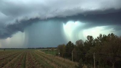
Severe weather conditions often hinge on the presence and structure of upper-level winds. One of the most important mechanisms is the process known as wind shear, which is a change in wind speed and/or direction with height. Wind shear creates an environment conducive to severe thunderstorms by allowing storm updrafts to tilt and rotate, thus preventing storm collapse and facilitating the organization of supercells.
Supercells are rotating thunderstorms that are often responsible for the most violent weather, including large hail, damaging winds, and tornadoes. The vertical wind shear provided by upper-level winds helps sustain these storms over extended periods by continuously feeding them warm, moist air at lower levels while venting out air at high levels.
Jet Streams as Steering Currents
The upper-level jet streams serve as steering currents that influence the path and speed of surface weather systems including cold fronts, warm fronts, and low-pressure systems. When a jet stream dips southward, it often drags cold, dry air masses into warmer regions, increasing the temperature gradient and instability in the atmosphere. This scenario enhances the likelihood of severe thunderstorms or even winter storms, depending on the season.
Additionally, jet streaks—areas of maximum wind speed within the jet stream—can create regions of divergence aloft. Divergence at upper levels promotes rising motion in the atmosphere, which aids thunderstorm development by reducing pressure at the surface and encouraging surface air convergence.
Upper-Level Winds and Tornado Development
Tornado formation is closely linked to specific upper-level wind patterns. Strong directional wind shear, where winds turn clockwise with height, creates horizontal rotation in the lower atmosphere. Thunderstorm updrafts then tilt this horizontal rotation into the vertical, forming the rotating mesocyclone core inside a supercell thunderstorm. Without significant upper-level wind shear, the organization necessary for tornado formation is typically absent.
Moreover, strong upper-level winds contribute to the intensification and longevity of these mesocyclones. The balance between updraft strength and wind shear determines whether a tornado will form and how powerful it may become.
Case Studies: Influences of Upper-Level Winds in Historic Severe Weather
Several historic severe weather outbreaks highlight the crucial influence of upper-level wind patterns. For example, the 2011 Super Outbreak in the United States featured a potent jet stream with strong wind shear, which helped spawn over 300 tornadoes in a few days. Detailed analysis showed that upper-level winds created an environment supportive of intense, long-lived supercell thunderstorms.
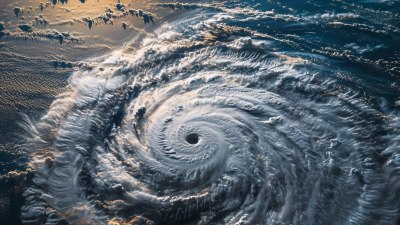
Similarly, the formation and path of Hurricane Harvey in 2017 were heavily influenced by upper-level steering currents. The slow-moving nature of the hurricane over Texas was linked to a blocking high-pressure system at upper levels combined with weak steering winds, leading to catastrophic flooding.
Prediction and Observation Methods
Meteorologists rely on various tools to observe and forecast upper-level winds. Weather balloons equipped with radiosondes ascend through the atmosphere, providing vertical profiles of wind speed and direction. Additionally, satellite-based wind measurements employ cloud tracking and Doppler radar techniques to estimate winds at higher altitudes.
Numerical weather prediction models integrate upper-level wind data to simulate the atmosphere’s behavior. Forecasting the position and strength of jet streams and related features is essential to anticipating severe weather outbreaks. Advances in computer power and remote sensing have significantly improved these capabilities over recent decades.
Impact on Weather Modification and Aviation
Understanding upper-level winds is important beyond meteorology alone. For aviation, upper-level winds determine flight routes for both cost and safety. Pilots utilize tailwinds in the jet stream to reduce fuel consumption and flight times, while turbulence often occurs near sharp changes in upper-level wind speed or direction.
Regarding potential weather modification techniques, some experimental approaches consider manipulating upper-level winds to influence storm development. While this remains largely theoretical, it underscores the importance of continuously improving our understanding of atmospheric dynamics.
Challenges in Studying Upper-Level Winds
The upper atmosphere is less accessible than surface conditions, making data collection inherently challenging. Balloon launches can only sample a snapshot in time and space, and satellite retrievals face limitations in resolution and accuracy.
Furthermore, upper-level wind patterns are highly variable and can change rapidly. Capturing these fluctuations and translating them into reliable forecasts remains a primary challenge for atmospheric scientists.
Integrating Upper-Level Wind Knowledge into Severe Weather Preparedness
Incorporating insights about upper-level winds into public warning systems enhances community resilience. By identifying wind shear and jet stream configurations favorable for severe weather, meteorologists can issue timely watches and warnings.
Emergency managers can use this information to allocate resources and plan evacuations when necessary. Educating the public about the science behind severe weather also helps reduce panic and misinformation during extreme events.
Future Directions in Research
Emerging technologies such as drones and advanced satellite instruments promise to deepen understanding of upper-level winds. High-resolution models coupled with machine learning algorithms will improve forecast accuracy and lead times.
Collaboration between meteorologists, climatologists, and engineers will foster innovations that enhance both prediction and mitigation of severe weather impacts.
Upper-level winds are a key driver behind the formation, development, and severity of many forms of severe weather. Their influence on storm dynamics, paths of weather systems, and the organization of thunderstorms place them at the heart of atmospheric science research. Expanding our comprehension and predictive capabilities related to upper-level winds directly benefits society by saving lives, reducing property loss, and improving the efficiency of weather-sensitive operations.