How Updrafts and Downdrafts Create Storm Intensity
Explore how the interaction of updrafts and downdrafts influences the intensity and development of storms, driving severe weather events.
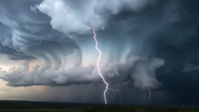
Storms are dynamic systems driven by various atmospheric processes, among which updrafts and downdrafts play pivotal roles. Understanding how these vertical air motions interact helps meteorologists predict storm intensity and potential severity. This article explores the mechanisms by which updrafts and downdrafts contribute to storm formation, growth, and dissipation.
Basics of Updrafts and Downdrafts
Updrafts are upward currents of air that result from localized heating of the Earth's surface, causing warm air to rise due to its lower density relative to surrounding cooler air. Conversely, downdrafts are downward air currents where cooler, denser air sinks toward the surface. These vertical motions facilitate the transport of heat, moisture, and momentum within storm systems.
In thunderstorm dynamics, updrafts typically draw in moist, warm air, which cools and condenses when it ascends, forming clouds and precipitation. Downdrafts, on the other hand, are associated with the downward movement of cooler air often cooled by evaporation of rain, bringing gusty winds at the surface and contributing to storm outflow.
Formation of Thunderstorms
The initial stage of thunderstorm development relies heavily on strong updrafts. Surface heating produces buoyant parcels of air that ascend, lifting moisture-laden air into the cooler upper atmosphere. As air rises and cools to its dew point, clouds form, initiating condensation and releasing latent heat. This heat further fuels the updraft, creating a positive feedback loop that strengthens the storm.
During this cumulus stage, updraft intensity governs the storm's growth. If the updraft is strong enough to sustain lifting beyond the condensation level, it can result in the towering cumulonimbus cloud typical of thunderstorms. The moisture condenses into water droplets or ice crystals, serving as the building blocks for precipitation.
Role of Downdrafts in Storm Development
Downdrafts form as cooler, denser air descends, often accelerated by cooling from rain evaporation in the storm's mid-levels. The descending air creates a region of negative buoyancy that pushes air downward toward the surface, producing gust fronts—sharp boundaries where the downdraft air meets the surrounding environment.
Downdrafts carry precipitation downward, and the brisk surface winds they generate can enhance turbulence and trigger new convection cells by lifting warm surface air. This interplay is vital for the organization and longevity of storms. In particular, downdrafts help regulate the storm’s life cycle by eventually cutting off the updraft’s supply of warm, moist air leading to storm dissipation.
Mesoscale Convective Systems and Vertical Air Movement
In large thunderstorm complexes such as Mesoscale Convective Systems (MCSs), the balance between updrafts and downdrafts determines structure and intensity. Strong updrafts concentrate moisture and energy, while downdrafts help organize the precipitation and influence storm propagation.
The propagation is driven by the cold pool created by downdrafts at the surface, which spreads outward, lifting warm, moist air and spawning new updrafts. This self-sustaining mechanism can lead to extensive, powerful storm systems lasting several hours or more.
Updraft Strength and Severe Weather
The velocity and duration of updrafts are key indicators of storm severity. Strong, persistent updrafts can suspend large water droplets and hailstones, allowing them to grow before falling. This process can lead to significant hail and intense precipitation.
Moreover, the vertical wind shear—a change in wind speed or direction with height—can tilt and organize the updraft, contributing to the development of supercell storms capable of producing tornadoes. The updraft's ability to sustain itself while rotating is critical for severe weather formation.
Downdrafts, Cold Pools, and Severe Wind Gusts
Downdraft-induced cold pools on the surface often generate damaging straight-line winds during severe thunderstorms. These downbursts result when descending air accelerates, strikes the ground, and spreads out rapidly, producing gust fronts with wind speeds that can exceed hurricane force.
Such cold pools also play a role in triggering new storm cells by lifting warm air ahead of the gust front, perpetuating the convective cycle. Severe downdrafts can also disrupt the existing updraft, influencing whether a storm strengthens or weakens.
Interactions Between Updrafts and Downdrafts
The interplay between updrafts and downdrafts determines the storm’s structure and life span. Updrafts supply the storm with moisture and energy, while downdrafts redistribute precipitation and alter the local environment through cooling and wind shear.
When a storm’s downdrafts become too dominant, they can choke off the warm air inflow that sustains the updraft, leading to storm weakening. Conversely, if updrafts maintain dominance, the storm can intensify and persist. This balance is dynamic and sensitive to environmental conditions such as humidity, temperature profiles, and wind shear.
Microphysical Processes within Updrafts and Downdrafts
Within the updraft, water vapor condenses into liquid droplets and ice particles through nucleation and riming. These microphysical transformations release latent heat, which fuels further ascent. Ice-phase processes, such as the Bergeron-Findeisen mechanism, enhance precipitation growth in colder storm regions.
In downdrafts, raindrops may evaporate partially, cooling the air and increasing its density, thus accelerating the downward air motion. This evaporative cooling is a major driver of downdraft strength and subsequent cold pool development at the surface.
Environmental Factors Affecting Updrafts and Downdrafts
Several atmospheric parameters influence the intensity of vertical air motions. Instability, quantified by Convective Available Potential Energy (CAPE), determines the buoyancy of updrafts. High CAPE values suggest strong potential updrafts capable of penetrating high into the atmosphere.
Wind shear also influences updraft sustainability and orientation, with strong vertical shear favoring longer-lived, organized storms. Moisture availability affects both vertical motions by providing fuel for condensation and evaporation processes.
Storm Initiation and Trigger Mechanisms
Surface boundaries such as cold fronts, dry lines, or sea breezes often act as triggers for storm formation by forcing warm air upward. When an updraft initiates along these boundaries, downdrafts develop shortly afterward as precipitation forms and begins to fall.
The timing and intensity of these vertical motions modulate how aggressively a storm develops and whether it can attain severe status. Early and strong downdrafts can suppress storm growth by disrupting the updraft, while delayed and moderate downdrafts may allow the storm to mature fully.
Updrafts, Downdrafts, and Tornado Genesis
In supercell thunderstorms, strong rotating updrafts known as mesocyclones provide the necessary environment for tornado formation. Downdrafts in these storms, such as the Rear-Flank Downdraft (RFD), help focus rotation near the surface and can either enhance or inhibit tornado genesis depending on strength and temperature.
The interaction between these vertical air currents shapes storm dynamics on fine spatial scales, influencing the tornadic potential and lifecycle. Proper understanding of these interactions aids forecasting and warning efforts during severe weather outbreaks.
Advanced Observation and Modeling Techniques
Meteorologists utilize Doppler radar, wind profilers, and atmospheric soundings to observe updraft and downdraft properties in real time. Numerical weather prediction models simulate these vertical currents to forecast storm initiation, structure, and intensity.
High-resolution models can capture the fine-scale turbulence and thermodynamics driving updraft and downdraft formation. These tools improve understanding of storm behavior, enabling more accurate predictions of threats like hail, damaging winds, and tornadoes.
Implications for Weather Warning and Safety
Recognizing the signatures of strong updrafts and downdrafts allows forecasters to issue timely warnings for severe storms. Rapidly strengthening updrafts may signal the development of intense hail and tornadoes, while robust downdrafts often indicate damaging wind threats.
Public safety depends on effective communication about storm intensity related to these vertical air motions. Awareness reduces risk and prepares communities for quick action in hazardous conditions.
Storm Dissipation and the Role of Downdrafts
As downdrafts intensify, they can dominate the convective system, cutting off the warm, moist inflow that sustains the updraft. This process leads to the weakening and eventual dissipation of the storm.
Precipitation loading, where the weight of precipitation inhibits vertical motion, further contributes to storm decay. Downdrafts enclosing the storm core may also introduce stable air that hinders further development.
The Balance of Vertical Air Motions in Storm Evolution
The life cycle of storms is a delicate balance between updrafts and downdrafts. Early storm stages are dominated by vigorous updrafts that promote growth, while mature and dissipating stages see downdraft influences becoming stronger.
Storm longevity depends on environmental conditions and internal dynamics that optimize this balance. Understanding this interplay is essential for advancing meteorological science and practical forecasting.
Summary of Mechanics Driving Storm Intensity
Updrafts transport warm, moist air upward, releasing latent heat that energizes the storm. Downdrafts bring cooled air downward, producing gust fronts and surface winds that can either sustain or disrupt convection. The intricate interaction between these vertical flows governs storm size, organization, severity, and duration.
Studying these processes provides insight into severe weather phenomena and supports efforts to minimize their societal impact through improved forecasting and mitigation strategies.