How Nor’easters Are Born and Why They Love the Atlantic Coast
Explore how Nor’easters form and why they frequently impact the Atlantic Coast with powerful storms.
Nor’easters are some of the most dramatic and powerful storms that batter the eastern coast of the United States, especially during the cold months. These large cyclonic storms can bring heavy snow, rain, strong winds, and coastal flooding, deeply affecting communities along the Atlantic Coast. Their formation, evolution, and repeated targeting of the Atlantic seaboard are driven by unique atmospheric and oceanic conditions. Understanding these elements requires examining meteorological fundamentals, geography, and ocean currents that combine to nurture this infamous weather phenomenon.
What Defines a Nor’easter?
The term "Nor’easter" refers to a type of storm named for the direction of its strongest winds, which typically blow from the northeast during the storm's most intense phase near the shore. These storms usually develop during late fall, winter, and early spring, although they can occur outside this timeframe. Nor’easters are technically extratropical cyclones, which means they form outside the tropics and are driven by temperature contrasts and other dynamic factors rather than the heat energy fueling tropical hurricanes.
One signature of Nor’easters is the strong, counterclockwise circulation around a low-pressure center, producing northeast winds on the coastal side. The storms often move parallel to or just offshore of the Atlantic Coast, impacting states from Florida all the way to New England and even Canada. Variability in intensity and precipitation type depends on the storm track, water temperatures, and interaction with other weather systems.
Atmospheric Ingredients for Nor’easter Development
Nor’easters form when several atmospheric conditions align. First, they often develop where cold, dry air from the continent meets warmer, moist air over the Atlantic Ocean. This temperature gradient creates instability and acts as the initial energy source as moist air rises and condenses.
Second, the presence of an upper-level disturbance, like a trough in the jet stream, helps excavate or deepen a low-pressure area at the surface. Upper-level jet streaks and wind shear patterns can enhance the rising motion of air in the storm's center, allowing the low pressure to intensify rapidly.
Third, these storms form near the East Coast corridor where the Appalachian Mountains and the coastal plain influence airflow patterns, often helping to steer the developing low-pressure system northeastward along the coast rather than inland.
The Role of Ocean Waters and Coastal Geography
The Atlantic Ocean plays a crucial role in nor'easter formation and intensification. During winter months, ocean waters off the East Coast remain warmer than the land and the air above it, providing a reservoir of moisture and heat. When cold air masses push off the continent, they move across relatively warmer ocean surfaces, picking up moisture. This enhances precipitation rates and storm energy.
The Gulf Stream, a strong ocean current that flows northward along the mid-Atlantic coastline, provides an especially important heat source. Storms moving near the Gulf Stream can strengthen and maintain their intensity due to this warm water input.
Additionally, the shape of the coastline funnels and guides storm systems. The northeast-southwest orientation of the coast tends to steer lows along this path. The presence of the continental shelf changes sea state and influences coastal flooding and wave action during Nor’easters.
Stages of Nor’easter Formation
The genesis of a Nor’easter begins with a weak low-pressure area—often forming from a stalled front or a decaying storm—off the southeastern United States or near the Gulf of Mexico. This initial low encounters the contrasting air masses over the ocean. As upper-level winds interact with the low, surface pressure drops and the low intensifies.
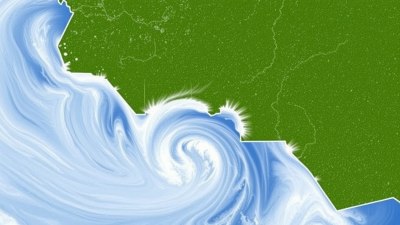
This deepening low-pressure area organizes around a tight center of cyclonic flow. Moist air is drawn from the ocean, rises, cools, and condenses into clouds and precipitation. The snow or rain bands wrap around the low, sometimes creating the classic "comma-shaped" cloud patterns visible on satellite imagery.
Depending on the temperature profile, areas northwest of the low center typically experience heavy snow, while regions closer to or southeast of the center get rain or mixed precipitation. Winds pick up, particularly on the coastal side where the pressure gradient is steepest, blowing from the northeast and driving coastal waves and flooding.
Typical Tracks and Variability of Nor’easters
Nor’easters generally form off the Southeastern U.S. coast and track northeastward parallel to the shore. Their path controls the type and severity of impacts. If the storm tracks very close to the coast or slightly inland, it can bring heavy snow to major population centers like New York City, Boston, and Philadelphia. A track farther offshore often results in rain and wind with less snow inland but significant coastal flooding.
These storms also vary in duration. Some last just 24 hours, while others may persist for several days. Storms can also stall, dumping prolonged heavy snow or rain on affected areas. In rare cases, Nor’easters can become just as damaging as hurricanes in terms of wind speeds, storm surges, and overall destruction.
Impacts of Nor’easters on the Atlantic Coast
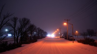
When Nor’easters hit, the consequences can be substantial. Heavy snow can accumulate rapidly, leading to transportation disruptions, power outages, and increased accident risks. Coastal flooding and erosion degrade beaches and threaten waterfront infrastructure. High winds cause damage to trees, buildings, and power lines.
Marine interests face hazards from high seas and hazardous coastal conditions. Emergency management must monitor these storms closely due to potential life-threatening impacts like flooding, hypothermia, and isolation.
Why the Atlantic Coast is a Hotspot for Nor’easters
The East Coast’s geography and climate position it as a prime location for Nor’easters. The contrast between frigid continental air masses from Canada and the warm Atlantic waters creates a natural source of storm energy. The coastal orientation guides storms up the shore, sometimes intensifying as they maintain proximity to the heat and moisture of the ocean.
The seasonal shift in the jet stream during fall, winter, and early spring provides the necessary upper-level dynamics to generate and maintain these cyclones. In contrast, other parts of the United States lack the combined presence of cold continental air and warm ocean currents, making Nor’easters a particularly regional phenomenon.
Comparing Nor’easters with Other Storms
Nor’easters differ from hurricanes, which are tropical cyclones fueled primarily by warm ocean water and latent heat release within a closed circulation. Nor’easters are extratropical, deriving energy from temperature contrasts and dynamic atmospheric factors rather than purely ocean heat.
Unlike winter blizzards that might be locally generated and smaller in scale, Nor’easters can span hundreds of miles with broad impacts. Hurricanes generally occur in summer and fall, while Nor’easters mostly develop in colder months.
Forecasting Challenges and Technological Advances
Forecasting Nor’easters remains challenging due to their complex interactions between atmospheric layers, ocean conditions, and terrain. Numerical weather prediction models have improved dramatically but still struggle with precise storm track and intensity forecasts beyond a few days.
The integration of satellite data, radar, buoys, and aircraft reconnaissance has enhanced real-time monitoring. Advances in computer modeling allow meteorologists to simulate various scenarios, aiding preparation and response. Early warnings save lives and reduce damage when these powerful storms approach.
Societal Preparedness and Adaptation
Communities along the Atlantic Coast have developed protocols for Nor’easter preparedness, including evacuation plans, snow removal strategies, and infrastructure designed to withstand heavy snow and flooding. Public awareness campaigns educate residents about the risks and safety measures.
With climate variability influencing storm patterns, ongoing research focuses on how Nor’easter frequency and intensity may change. Coastal resiliency planning incorporates these findings to better adapt to future challenges.
Nor’easters remain a defining feature of the Atlantic Coast’s weather, showcasing the complex forces of nature that form and steer large-scale storms. Through science, observation, and preparedness, society continues to better understand and coexist with these powerful atmospheric engines.