How Isentropic Lift Drives Widespread Cloud Cover
Explore how isentropic lift causes extensive cloud formation by uplifting air masses and triggering condensation on a large scale.

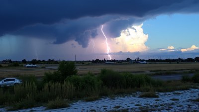
Image created with Flux Schnell
Understanding the formation of widespread cloud cover is fundamental to meteorology and climate science. One of the key processes that drive extensive cloud formation is isentropic lift, a phenomenon that involves the ascent of air parcels along surfaces of constant potential temperature. This process significantly influences weather patterns, precipitation, and atmospheric dynamics.
Isentropic lift occurs when air moves horizontally along a sloping surface of equal potential temperature, called an isentropic surface, and is forced to ascend due to terrain or synoptic-scale atmospheric motions. Unlike convective lift, which is driven by buoyancy and vertical instability, isentropic lift is largely associated with large-scale, stable air movements and the gradual forcing of air parcels to higher altitudes.
The concept of isentropic surfaces is essential to grasping isentropic lift. Potential temperature is the temperature an air parcel would have if brought adiabatically to a standard reference pressure, usually 1000 hPa. Surfaces where potential temperature is constant are called isentropic surfaces. Because air motion along these surfaces conserves entropy (in the absence of diabatic processes), air parcels tend to move horizontally along these layers. When these surfaces slope upward, air moving along them will rise isentropically, causing cooling and condensation.
As the air ascends along the sloping isentropic surface, pressure decreases and temperature drops at a rate determined by the adiabatic lapse rate. Cooling reduces the air parcel's capacity to hold water vapor, increasing relative humidity. Eventually, the air may reach saturation, leading to condensation and cloud formation. This process can generate widespread cloud cover, often observed in synoptic weather systems such as frontal zones and large-scale airflow over orographic features.
One of the classic manifestations of isentropic lift is observed in warm frontal zones. In these regions, warm air is advected over a cooler air mass along gently sloping isentropic surfaces. As the warm air is forced upward, clouds form extensively in a broad band ahead of the surface front. This widespread cloudiness often comprises stratiform clouds like nimbostratus and altostratus, which cover vast areas and contribute to prolonged precipitation events.
Isentropic lift also plays a crucial role in the development of stratiform clouds associated with upper-level troughs and ridges. The synoptic-scale motions lift air parcels along isentropic surfaces, leading to horizontal advection of moist air over cooler layers. The resulting ascents are gradual but extensive, favoring stable cloud layers rather than convective cells.
Furthermore, orographic lifting can interact with isentropic lift to enhance cloud formation. When moist air flows over mountain ranges, it is forced to rise along the underlying terrain (orographic lift). If this airflow also follows a sloping isentropic surface, the combined lifting mechanisms can amplify cooling and condensation, leading to persistent cloud cover on windward slopes, impacting regional climate and hydrology.
Quantifying isentropic lift's influence on cloud formation involves understanding the vertical and horizontal temperature gradients, humidity profiles, and airflow patterns. Atmospheric sounding data often reveal isentropic surfaces sloping upward, indicating regions susceptible to isentropic ascent. Satellite imagery and radar observations complement this by indicating cloud cover extent and type in such areas.
Isentropic analysis is valuable for weather forecasting as it helps predict precipitation areas, cloud extent, and frontal activity. Meteorologists use isentropic charts to track air parcel trajectories, moisture advection, and potential lifting regions, key for anticipating weather events such as widespread rain or snow.
To summarize the physical mechanism: parcels move along isentropic surfaces due to horizontal pressure gradients and large-scale wind fields. If these surfaces incline upwards with height, air parcels ascending the terrain cool adiabatically. Once dew point is reached, clouds form. Because the ascent is generally slow and extensive rather than rapid and localized, isentropic lift typically produces layered clouds over large areas.
This is markedly different from other lifting mechanisms like convective or frontal lifting associated with sharp gradients or buoyant instability. Isentropic lift is more subtle in onset but powerful in generating persistent cloud layers and precipitation over extensive regions, impacting the hydrological cycle and radiation budget in the Earth's atmosphere.
Moreover, isentropic lift is often linked to moisture convergence zones. As air ascends isentropically, convergence of moisture enhances relative humidity levels further, encouraging condensation. This effect, combined with the upward slope of isentropic layers, sustains cloud fields and even leads to the development of precipitation shield observed in warm sectors of midlatitude cyclones.
Advanced meteorological models incorporate isentropic lift dynamics to better simulate cloud formation and precipitation distribution. This improves the accuracy of weather forecasts, especially for events like warm frontal passages and large-scale precipitation outbreaks. Understanding the interplay of isentropic lift with other atmospheric processes aids in refining climate models, given its role in cloud-radiation interactions.
Isentropic lift's importance is also evident in tropical meteorology where sloping isentropic surfaces form due to large-scale circulation patterns, such as the Hadley cell. These lifts can lead to large stratiform cloud decks, contributing to the monsoon systems and Intertropical Convergence Zone (ITCZ) cloudiness.
In summary, isentropic lift is a fundamental and widespread mechanism in atmospheric dynamics that generates extensive cloud cover by slowly lifting moist air along sloped surfaces of constant potential temperature. This process creates stable, layered cloud structures associated with widespread precipitation, critical for weather systems worldwide.
Grasping how isentropic lift drives widespread clouds enhances meteorological diagnostics and enriches our understanding of Earth's climate system, precipitation mechanics, and atmospheric energy balance, making it an essential concept in weather prediction and climate science research.