Why Some Storms Spin and Others Don’t The Hidden Mechanics of Supercells
Explore the differences between spinning and non-spinning storms and the science behind supercells.
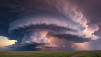
This image was created with the assistance of Freepik
Understanding the mechanics of thunderstorms is crucial for meteorologists, scientists, and anyone interested in severe weather patterns. Among the various types of storms, supercells stand out due to their structured and often violent nature. However, not all storms exhibit the spinning characteristics that define supercell formation. In this article, we delve into the reasons why some storms spin while others do not, examining the underlying physics and conditions that contribute to these differences.
What Are Supercells?
Supercells are a specific type of thunderstorm characterized by a rotating updraft. This rotation is driven by a combination of wind shear and thermal instability and can produce severe weather events like tornadoes, heavy hail, and intense rainfall. Unlike ordinary thunderstorms that are quick to form and dissipate, supercells can persist for hours, sometimes even producing multiple tornadoes and producing severe weather over a large area.
The Importance of Wind Shear
One of the critical factors that differentiate spinning supercells from non-spinning storms is wind shear. Wind shear refers to the change in speed or direction of wind at different altitudes. When there is a strong vertical wind shear, it creates an environment conducive to the rotation necessary for supercell formation. For instance, if the wind blows faster at higher altitudes compared to the surface, this variation can lead to a tilting of the horizontal rotation into a vertical axis, forming a rotating supercell.
Thermal Instability
In addition to wind shear, thermal instability plays a significant role in storm development. Thermal instability arises when warm, moist air at the surface rises and cools as it ascends. This process creates buoyancy that allows storms to develop. For supercells, the presence of warm, moist air combined with cold, dry air aloft enhances the potential for severe weather. If the atmospheric conditions are stable, storms are less likely to spin.
Environmental Factors Contributing to Storm Structure
A variety of environmental factors can influence whether a storm will develop into a supercell or maintain a simpler structure. These factors include moisture content, temperature gradients, and atmospheric pressure. Regions with warm, moist air interacting with cooler, drier air are more prone to supercell formation. For example, the Great Plains in the United States is an area frequently associated with supercells due to its conducive atmospheric conditions.
The Role of Topography
The geography of a region can also impact storm development. Areas with significant topographical features like mountains or valleys can disrupt airflow, leading to changes in wind direction and speed. This disruption can enhance wind shear and create conditions favorable for supercells. Conversely, flat terrains may allow for the formation of non-spinning storms, which do not exhibit the same level of organization or intensity.
Storm Lifecycle Stages
Understanding the lifecycle of a storm is essential to comprehend why some storms spin. Tropical storms and hurricanes can evolve into supercells, but not all do. Each storm can be categorized into stages: cumulus, mature, and dissipating. During the mature stage, if the environmental conditions allow, the storm can develop rotation, leading to a supercell. In contrast, if conditions are unstable or the storm encounters a stable layer of air, it may remain a non-spinning storm.
Significant Weather Phenomena Associated with Supercells
Supercells are often associated with extreme weather phenomena, including tornadoes, large hail, and flash flooding. The intense rotation in a supercell can create conditions that spawn tornadoes. When a rotating updraft meets the right conditions, a tornado can form, extending from the supercell down to the ground. Moreover, the size of hail can be significantly larger in supercells compared to non-spinning storms, attributed to the prolonged updrafts within these powerful storm systems.
Forecasting and Predicting Supercells
Accurate forecasting of supercells is essential for public safety, and meteorologists rely on advanced technology and models to analyze the atmospheric conditions. Doppler radar plays a crucial role in detecting rotation within storms, allowing forecasters to identify potential supercells and issuing warnings as necessary. Satellite imagery, surface observations, and numerical weather prediction models further enhance forecasting capabilities.
Continued Research and Advancements
Understanding the dynamics of supercells is a continuously evolving field, with researchers working to uncover the complexities of storm formation. New observational technologies and models provide deeper insights into the conditions that lead to spinning storms. Ongoing studies aim to improve predictive models, offer better guidance for public safety, and advance knowledge regarding storm behavior and damage potential.
The difference between spinning and non-spinning storms lies in various factors, including wind shear, thermal instability, environmental conditions, and geographical influences. Supercells represent a highly organized structure that requires specific atmospheric criteria for formation. As technology and knowledge advance, our understanding of these powerful weather phenomena continues to improve, helping to protect lives and property from their impacts.
