Why Pressure Gradients Create Strong Winds
Explore how pressure gradients drive strong winds by influencing air movement and weather patterns.
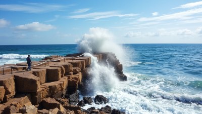
Image by valadzionak_volha on Freepik
Understanding why pressure gradients create strong winds involves examining the relationship between atmospheric pressure differences and the resulting air motion. In meteorology, wind is defined as the movement of air from regions of high pressure to regions of low pressure. The greater the difference in pressure, the stronger the force exerted to move air, which translates into stronger winds. This article delves into the fundamental principles of pressure gradients, how they generate wind, and their impact on weather systems.
Understanding Atmospheric Pressure
Atmospheric pressure is the force exerted by the weight of air molecules above a specific point on Earth's surface. It varies with altitude, temperature, and humidity. At sea level, the average atmospheric pressure is around 1013.25 hPa (hectopascals). Differences in atmospheric pressure across regions arise from factors such as uneven solar heating, variations in surface temperature, and the Earth's rotation.
These differences form what meteorologists call pressure gradients, which are critical in driving air movement. A pressure gradient refers to the rate at which atmospheric pressure changes over a certain horizontal distance. The steeper this gradient, the larger the difference in pressure between two adjacent areas.
The Concept of Pressure Gradient Force
The pressure gradient force (PGF) is the fundamental force responsible for initiating wind. It acts from areas of higher pressure toward lower pressure and is directly proportional to the magnitude of the pressure difference and inversely proportional to the distance between those differences. In essence, the PGF attempts to equalize pressure differences by moving air from high pressure zones to low pressure zones.
Mathematically, the pressure gradient force can be described as follows:
PGF = - (1/ρ) * ∇P
where ρ is the air density and ∇P represents the pressure gradient. The negative sign indicates that the force acts from high to low pressure. When this force acts on air molecules, it causes acceleration and the development of wind. The stronger the pressure gradient (steeper change of pressure over a short distance), the greater the PGF and the faster the winds.
How Pressure Gradients Develop
Pressure gradients develop primarily due to uneven heating of Earth’s surface by the sun. For example, during the day, land heats up faster than the ocean nearby, creating a low-pressure area over the land and a relatively higher pressure over the cooler ocean surface. This difference generates a pressure gradient that triggers the movement of air from the ocean toward the land, commonly known as a sea breeze.
Similarly, large-scale pressure gradients exist between polar and equatorial regions because of differences in solar intensity and resultant temperature variations. These gradients help produce planetary wind systems such as trade winds and westerlies.
Influence of the Coriolis Effect
The Coriolis effect, resulting from Earth's rotation, modifies the direction of winds generated by pressure gradients. While the pressure gradient force pushes air directly from high to low pressure, Coriolis deflects wind to the right in the Northern Hemisphere and to the left in the Southern Hemisphere. This deflection causes winds to flow parallel to isobars (lines of constant pressure) in many large-scale systems, forming what is called geostrophic wind.
In regions where the Coriolis force balances the pressure gradient force, winds flow smoothly along isobaric contours, contributing to consistent and sustained wind patterns like jet streams and dominant regional winds.
Role of Friction Near the Surface
Near Earth's surface, frictional force plays a significant part in modifying wind speeds and directions prompted by pressure gradients. Friction acts opposite to the movement of air and reduces wind speed, weakening the Coriolis effect's influence. As a result, winds near the surface cross isobars at an angle moving from high to low pressure rather than flowing strictly parallel to them.
Types of Winds Created by Pressure Gradients
Pressure gradients produce a wide variety of winds ranging from gentle breezes to powerful storms. Their characteristics depend on the steepness of the pressure gradient, altitude, topography, and other atmospheric conditions.
Local Winds: These include sea breezes, land breezes, and mountain-valley winds resulting from small-scale pressure differences caused by local heating or terrain.
Global Winds: Pressure gradients between large-scale pressure systems drive global wind patterns such as trade winds, westerlies, and polar easterlies. These winds regulate climate and weather worldwide.
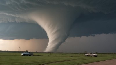
Storm Winds: Areas with very strong pressure gradients, such as hurricanes, cyclones, and tornadoes, exhibit intense winds. These gradients develop rapidly due to high temperature contrasts and energy release.
Pressure Gradients and Weather Systems
Pressure gradients are fundamental to the formation and behavior of weather systems. Low-pressure systems tend to create rising air, cloud formation, and precipitation, whereas high-pressure systems are associated with sinking air and fair weather.
Fronts, the boundaries between air masses of differing pressures and temperatures, often feature steep pressure gradients. These fronts lead to abrupt changes in wind, temperature, and humidity, frequently causing storms or other weather phenomena.
Storm intensity can be directly linked to the strength of associated pressure gradients. For instance, a hurricane’s strength depends on the difference in pressure between its eye (low pressure) and surrounding environment (higher pressure). A stronger gradient results in more violent winds and destructive potential.
Measuring Pressure Gradients and Winds
Meteorologists measure atmospheric pressure using barometers and observe pressure differences on weather maps through isobars. Closely spaced isobars indicate steep pressure gradients and predict strong winds, whereas widely spaced isobars suggest gentle gradients and mild winds.
Wind observations complement pressure data, allowing scientists to understand and forecast wind patterns, storm development, and potential hazards associated with strong winds.
In summary, pressure gradients cause strong winds because they represent differences in atmospheric pressure that create forces pushing air from regions of high pressure to low pressure. The greater the pressure difference over a given distance, the stronger the pressure gradient force, which accelerates air to higher wind speeds.
Additional factors such as Earth’s rotation (Coriolis effect) and friction near the surface influence the direction and speed of these winds, but the fundamental cause remains the pressure differences. Pressure gradients underlie all wind phenomena, shaping weather systems from gentle breezes to devastating storms.
By understanding pressure gradients and their meteorological implications, we gain insight into Earth's dynamic atmosphere and improve our ability to predict weather conditions.