What Happens in the Eye of a Hurricane: A Calm Like No Other
Explore the phenomena and dynamics of the eye of a hurricane, an area of extraordinary calm amidst chaos.

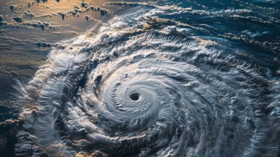
Image by user20248055 on Freepik
The eye of a hurricane is one of nature's most fascinating and paradoxical phenomena. While surrounding the eye is a whirling mass of fierce winds and torrential rains, the eye itself presents a stark contrast: a zone of calm and often clear skies. Understanding what happens in this unique area is crucial for grasping the full dynamics of hurricanes.
The eye is typically circular and can range from 20 to 40 miles in diameter, though it can occasionally be larger. It is formed when a tropical storm intensifies into a hurricane due to favorable environmental conditions. The development of an eye is a sign that the storm has reached maturity, and it indicates a well-structured system within the hurricane’s circulation.
Formation and Structure of the Eye
A hurricane begins as a tropical depression, which can develop into a tropical storm and eventually a hurricane when sustained winds exceed 74 miles per hour. As the storm matures, it establishes a well-defined center, where the eye develops. The eye is formed due to the conservation of angular momentum, leading to a lower pressure in the center, allowing air to sink rapidly into the eye.
This sinking air creates the calm conditions in the eye itself. While surrounding areas experience intense updrafts as warm, moist air rises, the air in the eye descends, leading to clearer skies and less precipitation. This descending air can also help to maintain the structural integrity of the eye, keeping it distinct from the storm's outer bands.
The Calm Within the Storm
As a hurricane approaches land, the eye can bring a deceptive sense of safety. For those caught in the storm, the transition from chaos to stillness can be jarring. The calm can last anywhere from a few minutes to over an hour, depending on the size and speed of the hurricane. This temporary lull can give people a false sense of security, leading to dangerous situations as the rear eyewall, often just as turbulent as the front, follows closely behind.
The winds in the eye can vary greatly, with typical speeds much lower than those of the surrounding hurricane. In many cases, wind speeds can drop significantly, leading to noticeable temperature changes as well. The environment feels eerily still, marked by an almost surreal quietness. Birds may even be seen flying about, taking advantage of the momentary reprieve.
The Role of the Eye in Hurricane Dynamics
Understanding the dynamics of the eye is essential for predicting hurricane behavior. The eye is often associated with the eyewall, which is the ring of thunderstorms that surrounds the eye. This structure is typically the most dangerous part of the hurricane, producing the most intense winds and precipitation. As such, the characteristics of the eye and eyewall are crucial indicators of the storm's strength and potential impact on landfall.
When the eye forms, it can signify that the hurricane is transitioning into a mature stage. The development of a well-defined eye is generally indicative of a strong system with a well-developed core. Meteorologists closely monitor these changes using Doppler radar and satellite imagery, which can help them forecast changes in intensity and movement.
The Connection Between the Eye and Environmental Factors
The formation and strength of the eye can be influenced by surrounding environmental conditions. Factors such as ocean temperatures, wind shear, and humidity play significant roles in the development of a hurricane. Warm ocean waters provide the necessary energy for hurricanes to strengthen and maintain the intensity of their eyewall. Conversely, high wind shear can disrupt the structure of a storm, making it difficult for a well-defined eye to form.
Additionally, the presence of dry air in the surrounding atmosphere can also lead to complications. If dry air is ingested into the circulating storm, it can weaken the eye and cause fluctuations in intensity. Understanding these environmental drivers is essential for forecasting future hurricanes, as conditions can change rapidly.
Impact on Coastal Areas
The eye's passage over land can have significant implications for coastal areas. The calm conditions provided by the eye can lure people outside, but the dangers associated with the rear eyewall can be severe. This part of the hurricane can bring devastating winds and rainfall that can lead to flooding and damage. Many disasters occur when people underestimate these conditions, leading to increased casualties and property loss.
Moreover, the storm surge associated with hurricanes often peaks along with the arrival of the eyewall, leading to catastrophic flooding. Understanding the dynamics of the eye can help urban planners and emergency services prepare for the extreme conditions brought by these storms. Ensuring that communities are aware of the potential dangers can save lives and minimize damage.
The Future of Hurricane Research
Ongoing research into hurricane formation and behavior aims to enhance understanding of eyes and their influences on the storms overall. Scientists are employing advanced technologies, including drones and satellites, to study hurricanes more closely. Gathering data from within the eye, and throughout the storm, can yield insights into its structure and dynamics.
As climate change continues to alter weather patterns, understanding the impacts this may have on hurricane behavior is more important than ever. Warmer sea surface temperatures tend to produce more intense storms, and capturing data regarding these changes will be crucial for future hurricane prediction models.
The eye of a hurricane is a captivating subject of study, representing both the beauty and ferocity of nature. Understanding what happens in the eye, the calm that can exist within chaos, and the potential dangers it embodies is essential for safety and preparedness. As scientists continue to explore the relationships between the eye of hurricanes, environmental factors, and hurricane behavior, we are better equipped to predict and respond to these powerful storms, ultimately reducing risk to life and property.


