What Freezing Rain Really Is and How It Forms
Understand freezing rain, its formation process, and the hazards it poses during winter weather conditions.
Freezing rain is a meteorological phenomenon that often causes hazardous conditions and significantly impacts transportation, infrastructure, and safety during winter months. While it is commonly mentioned in weather forecasts, many people confuse freezing rain with other types of winter precipitation such as sleet or snow. To appreciate the true nature of freezing rain, it is essential to understand exactly what it is, how it forms, and what makes it uniquely dangerous.
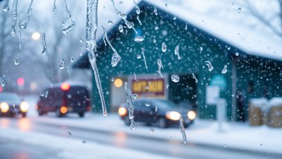
At its core, freezing rain is liquid precipitation that falls from the sky and then freezes upon contact with surfaces that are at or below the freezing point. Unlike snowflakes which remain solid throughout their descent, or sleet which partially refreezes into ice pellets while falling, freezing rain starts as snow high in the atmosphere but melts into rain before reaching the ground only to re-freeze instantly when it touches cold surfaces. This key characteristic makes freezing rain particularly treacherous on roads, power lines, trees, and other exposed objects.
The Atmospheric Conditions Needed for Freezing Rain
Freezing rain formation requires a very specific setup in the vertical temperature profile of the atmosphere. Typically, precipitation begins high in the atmosphere as snowflakes forming in a cloud layer where temperatures are well below freezing. As these snowflakes fall, they pass through a layer of air that is above freezing, often found closer to the surface. This warm layer causes the snow to melt completely into raindrops. However, before the raindrops reach the ground, they encounter a shallow layer of air at or below 0 degrees Celsius (32 degrees Fahrenheit) which is cold enough to freeze water on contact but not thick or cold enough to freeze the rain into sleet or ice pellets while still in the air.
This creates a unique situation where precipitation arrives as liquid rain but instantly freezes upon striking surfaces such as roads, trees, cars, or power lines that are cold enough to trigger quick freezing. The key difference between freezing rain and sleet is the depth and temperature of the cold layer near the surface. For sleet, the cold layer is thick and deep enough to freeze the liquid water droplets into small ice pellets before they land. For freezing rain, the cold layer near the surface is too shallow and not cold enough to freeze the droplets mid-air.
Typical Weather Patterns That Produce Freezing Rain
Freezing rain is most common during mid-winter and late fall or early spring when temperature contrasts between surface air and air above are prominent. A typical weather pattern that leads to freezing rain involves a warm front or a shallow warm layer aloft overriding a cold surface air mass. In these situations, warmer air is forced to ride above colder, denser air near the ground, creating the perfect vertical temperature profile for freezing rain.
This phenomenon often occurs during large-scale winter storms or ice storms, especially in mid-latitude regions where warm moist air from the south clashes with cold air trapped at the surface. A classic example is when a warm southerly flow aloft moves over a region where cold air is trapped by a valley or surface high pressure. The result is precipitation falling initially as snow, melting into rain while passing through the warm mid-levels of the atmosphere, and then freezing instantly when touching frozen surfaces near the ground.
The Physical Process of Freezing on Surfaces
The freezing of rain on contact involves a phase change from liquid water to solid ice that releases latent heat. When freezing rain hits a cold surface, such as a road or a tree branch, the water droplets lose heat rapidly due to the low temperature of the substrate. This sudden loss of heat causes the water to supercool temporarily before crystallizing and forming a smooth, transparent glaze of ice, often referred to as glaze ice or glaze.
Unlike sleet which strikes the ground as hard, pea-sized pellets of ice, freezing rain coats surfaces with a slick layer of ice that can accumulate quickly, leading to dangerous conditions. The ice can add significant weight on power lines and tree branches, causing them to bend, snap, or break. On roads and walkways, the smooth ice layer hides underlying pavement texture, greatly increasing slip and fall accidents and vehicle crashes.
Freezing Rain vs. Other Types of Winter Precipitation
Clear understanding of freezing rain requires differentiating it from other winter precipitation types, primarily sleet and freezing drizzle. While these all involve freezing processes, their formation and hazard profiles differ.
Sleet begins as snow but melts into rain only partially within a shallow warm layer aloft, then refreezes into small ice pellets before reaching the surface. These pellets bounce when they hit the ground and do not create the smooth ice coating typical of freezing rain. Sleet can accumulate but usually does not cause the same level of glaze icing hazards.
Freezing drizzle is drizzle—very small liquid water droplets—that freeze upon contact with surfaces below freezing, similar to freezing rain. The difference lies primarily in droplet size and precipitation intensity. Drizzle droplets are smaller and precipitation rates are lighter. Despite this, freezing drizzle can still produce dangerous ice accumulations.
Snow remains frozen throughout its descent and does not pass through deep warm layers. Snow accumulation, while affecting visibility and travel, does not create slick glazed surfaces that freezing rain does.
Forecasting Challenges and Warning Implications
Predicting freezing rain accurately is challenging for meteorologists due to the fine-scale vertical temperature profile it requires. Small changes in thickness and temperature of warm and cold layers can result in drastically different precipitation types: snow, sleet, freezing rain, or rain. Surface temperatures near freezing may differ by a degree or two across a region, altering the freezing rain risk.
Modern numerical weather prediction models incorporate detailed temperature soundings and atmospheric profiles but can still struggle with exact placement of freezing rain zones. Weather forecasters rely on temperature data from upper-air balloons, ground observations, and model simulations to issue freezing rain advisories or ice storm warnings.
Since freezing rain can create quickly accumulating glaze ice even with relatively light precipitation rates, public warnings often emphasize the potential for dangerous travel conditions, power outages, and damage to trees and infrastructure. Ice storm warnings are usually issued when an accumulation of ice from freezing rain is expected to exceed a quarter-inch or more on exposed surfaces.
Safety Tips and Precautions for Freezing Rain Events
During a freezing rain event, it is critical for the public to take extra precautions to prevent accidents and damage. Drivers must exercise extreme caution as roads can become coated with invisible ice making vehicles prone to skidding or losing control. Reducing speed, increasing following distance, and avoiding sudden braking or acceleration are essential.
Pedestrians should be aware of dangerously slick sidewalks and walkways, wearing appropriate footwear and avoiding unnecessary travel. Investing in ice melt or sand to improve traction around walkways can help reduce slips and falls.
Property owners should monitor power lines and tree limbs for excessive ice accumulation. Tree branches bearing heavy ice may break unexpectedly, posing safety risks and potential property damage. Trimming trees near power lines and securing loose objects outdoors are preventative steps.
Emergency preparedness is also key during prolonged ice storms. Power outages from freezing rain can last hours or days, so having backup heat sources, food supplies, and communication options is important to withstand extended outages safely.
Regional Climates and Frequency of Freezing Rain
Freezing rain does not occur uniformly around the world but is most common in certain climates and geographic features. In the United States, the northeastern states, the Great Lakes region, and parts of the Midwest frequently experience freezing rain, especially during winter storm episodes. Canada’s southern regions, particularly southern Ontario and Quebec, are also prone to frequent ice storms and freezing rain events.
Regions near mountains or valleys may see enhanced occurrences of freezing rain due to temperature inversions where cold air is trapped near the surface under warm air layers. Coastal areas where maritime air masses override colder land air can also generate the vertical temperature profile needed for freezing rain.
Environmental and Infrastructure Impacts of Freezing Rain
Besides immediate public safety concerns, freezing rain poses significant environmental and infrastructural challenges. The accumulation of glaze ice on vegetation can cause widespread tree damage, stripping branches or even uprooting entire trees. This not only affects natural ecosystems but also increases debris risks and cleanup costs.
Power utilities face significant challenges from glaze ice buildup on power lines and poles. The added weight can cause lines to sag or break, triggering outages. Repairing ice storm damage is costly and time-consuming, often requiring crews to work in dangerous conditions during continued cold weather.
Transportation infrastructure suffers as well. Ice-covered roads and bridges necessitate salting, sanding, and plowing operations that strain municipal resources. Airports may experience delays or cancellations due to icy runways and hazardous conditions for aircraft.
Technological Advances and Research on Freezing Rain
Ongoing meteorological research and advances in technology aim to improve prediction and mitigation of freezing rain impacts. Enhanced radar systems and satellite observations allow scientists to track storm systems and precipitation types with greater precision. Doppler radar signatures help identify melting layers and inform precipitation phase changes in real time.
Numerical weather models have become more sophisticated, incorporating higher resolution vertical data to better capture subtle temperature inversions that lead to freezing rain. Some research also explores the influence of climate change on freezing rain frequency and intensity, although the complex interactions remain an active area of study.
On the infrastructure side, improvements include the use of ice-resistant materials on power lines, installation of heated pavement technologies, and development of rapid ice detection systems to provide early warnings to maintenance crews. Public outreach campaigns also emphasize awareness and preparedness during freezing rain events.
Understanding what freezing rain really is and how it forms empowers individuals, communities, and agencies to respond effectively when ice storms occur. Recognizing the delicate atmospheric conditions that cause freezing rain highlights the complexity behind seemingly simple precipitation types and underscores the importance of detailed meteorological observation for safety and infrastructure protection.