What Cloud Layers Tell Us About Vertical Air Movement
Explore how different cloud layers reveal the dynamics of vertical air movement and atmospheric processes.
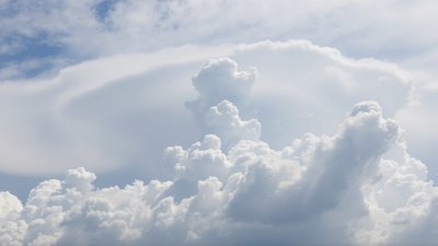
Image created with Flux Schnell
Clouds have fascinated humans for centuries, not only for their beauty but also for the wealth of information they offer about atmospheric behavior. One of the critical aspects meteorologists and enthusiasts observe is the layering of clouds in the sky. These cloud layers provide essential clues about vertical air movement, which is fundamental to weather formation, storm development, and climatic patterns.
The atmosphere is a dynamic system with air moving in various directions and speeds. Vertical air movement, or the rising and sinking of air parcels, plays a pivotal role in forming clouds and precipitation. When air rises, it cools and expands, leading to condensation of water vapor into cloud droplets or ice crystals. Conversely, sinking air tends to warm and dry, suppressing cloud formation. By examining cloud layers, their thickness, type, and arrangement, we can infer the vertical currents shaping them.
Types of Clouds and Their Typical Altitudes
Before delving into how cloud layers inform us about vertical air movement, it’s essential to understand the basic cloud classifications. Clouds are typically categorized based on their altitude and appearance into high, middle, and low clouds.
High clouds, such as cirrus, cirrostratus, and cirrocumulus, generally form above 20,000 feet (6,000 meters). They are composed mostly of ice crystals due to the colder temperatures at these heights. Middle clouds, like altostratus and altocumulus, form between 6,500 and 20,000 feet (2,000 to 6,000 meters) and are mainly composed of water droplets, sometimes mixed with ice crystals. Low clouds, including stratus, stratocumulus, and nimbostratus, form below 6,500 feet and contain water droplets.
There are also clouds with vertical development, such as cumulus and cumulonimbus, which can span multiple layers, from low to very high altitudes, indicating strong vertical air currents.
Single vs. Multiple Cloud Layers
Sometimes the sky features a single, uniform cloud layer, while other times, multiple distinct layers are stacked at different altitudes. These patterns are significant for understanding vertical air movement.
A single cloud layer often suggests a relatively stable atmosphere with limited vertical mixing. For example, a widespread stratus deck points to a shallow, moist layer with gentle vertical motions insufficient to produce towering clouds.
Multiple cloud layers, however, imply a more complex vertical profile with varying stability and moisture conditions at different heights. These layers can arise when air masses at different altitudes exhibit distinct temperature and moisture characteristics, or when multiple weather systems interact. The presence of multiple cloud decks frequently signals active vertical air movement, with rising air parcels in some layers and subsidence (sinking air) in others.
Implications of Thin, Wispy High Clouds
Thin, filmy high clouds such as cirrus often indicate upper-level atmospheric motions. These clouds form from ice crystals, typically shaped by gentle lifting of moist air in the upper troposphere. When cirrus clouds appear in streaks or fibrous strands, it usually reflects strong upper-level winds that shear the ice crystals horizontally.
Widespread thin cirrostratus can signal the approach of a warm front, involving gradual lifting of air over a large area. This lifting is relatively gentle and sustained, resulting in the formation of extensive high-level cloud layers before lower clouds develop. Observing these wispy clouds lets meteorologists anticipate vertical motions that precede larger weather changes.
Cumulus Clouds and Vertical Convection
Cumulus clouds are classic indicators of active localized vertical air movements. These puffy, cotton-like clouds form as surface air heats and rises in thermals. During sunny, warm days, the sun warms the Earth’s surface unevenly, causing warm parcels of air to ascend vigorously, condensing moisture into cumulus clouds.
The shape and growth of cumulus clouds reveal the strength of upward motion. Small, scattered cumulus clouds suggest moderate vertical air currents, usually resulting in fair weather. If these clouds grow taller and larger, sometimes developing into towering cumulus or cumulonimbus, it indicates robust updrafts capable of producing thunderstorms.
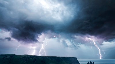
Cumulonimbus Clouds: Vertically Extensive Turbulence
Cumulonimbus clouds represent the most dramatic display of vertical air movement. These thunderstorm clouds can reach heights of 60,000 feet or more, spanning multiple atmospheric layers from near the surface to the stratosphere. The intense rising air currents within cumulonimbus clouds generate severe weather phenomena such as heavy rain, hail, lightning, and tornadoes.
The structure of cumulonimbus clouds often includes distinctive features like an anvil-shaped top, formed when the rising air hits a stable layer in the upper atmosphere and spreads horizontally. The presence of such extensive vertical cloud development reveals intense convective activity and unstable atmospheric conditions.
Layered Clouds with Embedded Vertical Motion
Sometimes, cloud layers can appear stratified but still indicate vertical motions within or between layers. For example, altostratus or nimbostratus layers frequently form from steady, moderate vertical ascent over a wide region, such as ahead of a warm front or in a broad low-pressure area. These layered clouds can produce prolonged precipitation and show sustained upward air movement, albeit weaker than within towering cumulonimbus clouds.
Embedded within these layers, local convective elements may develop to form small cumulus cloudlets, illustrating mixed vertical motions in a broader stratiform cloud environment. This can signal a transition phase in weather systems or evolving instability.
Cloud Layer Gaps and Atmospheric Stability
Gaps between cloud layers suggest variations in the vertical profile of temperature, moisture, and stability. For instance, a clear layer separating low and mid-level clouds often indicates a dry or stable layer where vertical motions weaken, preventing cloud formation.
Such gaps can act as barriers or 'caps' to upward movement. When the cap is strong, surface air parcels struggle to rise beyond lower levels, suppressing cloud vertical growth and storm development. When the cap weakens, air can rise more freely, allowing clouds to penetrate through multiple layers and possibly trigger severe weather.
Identifying Vertical Wind Shear Through Cloud Layers
Vertical wind shear — changes in wind speed or direction with height — can also be inferred from cloud layers. Cloud streets, rows of cumulus clouds aligned parallel to wind direction, develop in environments with steady shear and consistent vertical air movement. Multiple cloud layers with different motion directions and speeds can tilt or distort cloud formations, indicating wind shear’s presence.
This information is vital for aviation safety and storm prediction, as strong shear can organize convective storms, influence their severity, and create turbulence.
Using Cloud Layers for Forecasting
Understanding cloud layers allows meteorologists to make more accurate predictions about upcoming weather. By interpreting which layers show active vertical air movement and which display stability, forecasters assess the potential for precipitation, storm formation, or clear skies.
For example, the formation of multiple cloud layers at various heights often precedes changes in weather patterns, suggesting increasing instability and vertical mixing. On the other hand, persistent single layers or cloud-free skies imply stable conditions with limited vertical motion.
Satellite and Radar Observations
Modern weather monitoring technologies, including satellites and Doppler radar, complement visual cloud observations. Satellite imagery provides detailed views of cloud layers, their texture, and movements, revealing patterns of vertical air currents over vast regions. Radar can detect precipitation within cloud layers and the velocity of moving particles, offering insights into updrafts and downdrafts in convective storms.
Combining these tools with surface observations of cloud layering enhances the understanding of vertical air movement and improves weather forecasting models.
Environmental and Climatic Significance
Clouds influence Earth’s energy balance by reflecting sunlight and trapping infrared radiation. Vertical air movement governs cloud formation and type, thereby impacting local and global climate. Persistent cloud layers can stabilize or destabilize atmospheric conditions, affecting temperature ranges and moisture cycles over time.
Patterns of vertical air movement inferred from cloud layers also contribute to understanding atmospheric convection, which drives large-scale weather systems like monsoons, hurricanes, and jet streams. In studying cloud layers, researchers gain critical insight into climate feedback mechanisms and potential shifts resulting from human-induced climate change.
Practical Applications Beyond Meteorology
Knowledge of cloud layering and vertical air movement benefits many fields beyond weather forecasting. Aviation relies heavily on understanding vertical air currents for flight safety and route planning. Meteorologists issue advisories about turbulence based on cloud formations and vertical movement indicators.
Environmental monitoring, agriculture, and renewable energy sectors also utilize data derived from cloud layer observations to predict rainfall, manage water resources, and optimize wind or solar power generation.
Cloud Layer Clues to Vertical Air Movement
In essence, cloud layers act as natural signposts revealing the vertical dynamics of the atmosphere. Thin, wispy high clouds indicate gentle upper-level ascent; cumulus clouds mark localized thermals and convection; towering cumulonimbus clouds signal intense vertical currents and storm activity; while multiple cloud layers suggest complex vertical structure with varying stability and moisture.
Gaps between layers represent stable or dry air hindering vertical motions, and wind shear manifests through cloud alignment and layering changes. Recognizing these patterns enables better comprehension of atmospheric processes and enhances forecasting accuracy, ultimately aiding society in planning and safety.
By observing the sky and understanding what cloud layers tell us about vertical air movement, we connect visually with the invisible forces that shape our weather and environment.