What Causes Shelf Clouds Ahead of Storms
Explore the causes and formation of shelf clouds that appear ahead of storms, revealing nature's dramatic weather phenomena.
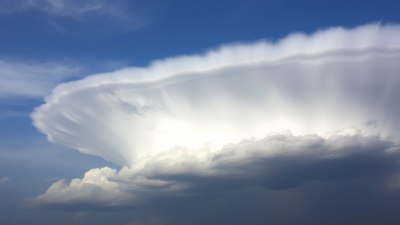
Image created with Flux Schnell
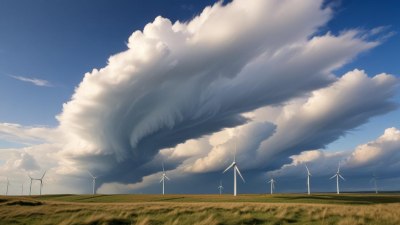
Shelf clouds are among the most striking and dramatic weather phenomena observed ahead of thunderstorms. These horizontal, wedge-shaped clouds signal the arrival of intense weather, often preceding gusty winds, heavy rain, and even severe thunderstorms. But what exactly causes shelf clouds to form, and why are they positioned ahead of storms? Understanding the physical processes behind shelf clouds involves delving into the interaction between different air masses and the dynamics of storm systems.
Defining Shelf Clouds
Shelf clouds are low, horizontal, wedge-shaped cloud formations typically attached to the base of a thunderstorm's leading edge, known as the gust front or outflow boundary. Visually, shelf clouds appear as a dense, dark cloud bank with a sharp, often scalloped lower edge that seems to rise dramatically from the horizon toward the sky. This distinct formation creates a visual cue signaling an impending change in weather conditions.
Unlike wall clouds, which form within the storm and can generate tornadoes, shelf clouds form outside the main storm updraft and are associated mainly with the storm's downdraft region and outflow. Their position often makes them a harbinger of the severe weather that follows, such as strong winds, heavy precipitation, and turbulence.
The Role of Thunderstorm Dynamics
To comprehend why shelf clouds form, it is essential first to understand the dynamics of thunderstorms themselves. Thunderstorms develop due to the rapid upward movement of warm, moist air, which cools and condenses to form clouds and precipitation. This updraft region is typically found in the storm's core, where latent heat release fuels the storm's vertical growth.
Conversely, downdrafts occur when rain-cooled air descends toward the surface, pushing the colder, denser air outward and forward. This downdraft generates a gust front, a boundary marking the leading edge of the storm's outflow air. The gust front acts like a miniature cold front, advancing ahead of the storm and interacting with the surrounding warm, moist air.
Interaction Between Outflow and Warm Air
As the cold downdraft air spreads out horizontally along the ground, it encounters the warm, moist air in front of the storm. This interaction creates a lifting mechanism, as the denser cold air wedges underneath the lighter warm air, forcing the warm air to rise rapidly. The forced ascent of this warm, humid air cools it to its dew point, causing condensation and cloud formation directly ahead of the gust front. This rising warm air along the boundary creates the characteristic shelf cloud shape.
Thus, shelf clouds effectively represent the visible expression of the gust front’s leading edge, where strong lifting due to cold outflow and warm inflow results in cloud development. The steep slope of the cloud base reflects the abrupt transition from cold downdraft air near the surface to warm, moist air being lifted adiabatically.
Physical Processes Behind Shelf Cloud Formation
Several physical processes contribute to the formation of shelf clouds. Key among these is the concept of density difference and convergence at the gust front. The cold air outflow from the storm is denser and forces its way horizontally beneath the less dense warm air, creating a boundary or discontinuity known as the outflow boundary.
The warm air ahead of the gust front is converged and lifted because it cannot mix immediately with the intrusive cold air. As the warm air is lifted, water vapor condenses into tiny water droplets, forming the visible cloud. The rapid lifting and condensation cause a sharp cloud edge—the leading edge rises as it is lifted, creating the wedge-shaped cloud that is visually recognized as a shelf cloud.
Additionally, turbulence and shear generated at the interface between the cold outflow and warm inflow contribute to the cloud's ragged, scalloped lower edge. This turbulent mixing is responsible for the characteristic billowy structures sometimes observed along the shelf cloud’s leading edge.
The Influence of Atmospheric Stability
The broader atmospheric stability also influences shelf cloud formation. Atmospheric stability describes the tendency of air parcels to either resist or enhance vertical motion. When the atmosphere is conditionally unstable, the warm, moist air ahead of the gust front is more easily lifted, supporting the development of the shelf cloud.
If the atmosphere is very stable, strong uplift is suppressed, and shelf clouds may be less distinct or not form at all. Conversely, in an unstable atmosphere with high moisture content, the shelf cloud can become very pronounced as vigorous lifting enhances condensation, often signaling robust storm activity.
Role in Predicting Weather Changes
Shelf clouds serve as valuable visual indicators for meteorologists and storm observers. Their presence often precedes sudden weather changes attributable to the approaching thunderstorm. As the gust front advances, winds tend to shift direction abruptly, often increasing to strong, sometimes damaging, speeds.
Along with the telltale visual sign of an ominous cloud shelf, meteorologists monitor accompanying changes in temperature, pressure, and humidity associated with the gust front. A sudden drop in temperature and shift in wind direction are typical as the gust front moves through. These parameters, combined with the observation of a shelf cloud, help forecasters provide timely warnings about incoming severe weather.
Differences Between Shelf Clouds and Other Storm Clouds
It is important to distinguish shelf clouds from other similar storm cloud formations, such as wall clouds and roll clouds. A wall cloud is a lowering of the cloud base within the storm's updraft; it is often associated with tornadic activity and forms beneath the primary storm cloud base.
In contrast, shelf clouds attach to the storm's leading edge and are linked to the outflow boundary. Roll clouds are cylindrical and typically roll along a horizontal axis, detached from the main storm and more commonly associated with cold fronts or sea breezes rather than thunderstorms.
Recognizing these distinctions is crucial for properly interpreting storm behavior and potential hazards.
Environmental Conditions Favoring Shelf Cloud Formation
Several environmental conditions make shelf clouds more likely to form and be noticeable. These include:
- A strong and well-developed downdraft that generates a pronounced gust front.
- Warm, moist low-level air ahead of the gust front providing sufficient humidity for condensation.
- A sharp temperature and density contrast between the storm outflow and the ambient air.
- A relatively unstable atmosphere to promote quick lifting of the warm air.
- Clear skies ahead of the storm to allow the shelf cloud to be visually prominent.
When these conditions are met, shelf clouds are typically more dramatic and visually impressive, recruiting storm watchers’ and photographers’ attention.
Visual Characteristics and Observations
When observing a shelf cloud, several features can be noted:
- The cloud appears as a thick, dark horizontal band often stretching miles across the sky.
- Its leading edge may have a smooth or scalloped appearance due to turbulent air mixing.
- The base of the cloud is usually very low and may descend near the horizon.
- Turbulent gusts and sudden wind shifts often accompany the approach of the shelf cloud.
- The cloud frequently advances rapidly overhead, sometimes with a low rumble of thunder.
These characteristics make shelf clouds uniquely recognizable and excellent visual cues of approaching storms.
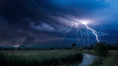
Shelf Clouds and Severe Weather Hazards
While shelf clouds themselves do not produce tornadoes, their presence indicates strong downdrafts and gust fronts that can generate significant weather hazards. These hazards include:
- Sudden, strong straight-line winds capable of damaging structures and uprooting trees.
- Abrupt temperature drops and shifts in wind direction.
- Heavy rain and hail accompanying the storm's arrival.
- Turbulent conditions that can affect aviation and outdoor activities.
Understanding these hazards helps both meteorologists and the public prepare for rapidly deteriorating weather conditions.
Scientific Research and Modeling
Recent advancements in meteorological research and computational modeling have improved understanding of shelf cloud formation. High-resolution numerical weather prediction models simulate downdraft and gust front dynamics, demonstrating how cold pool outflows lift warm air to form shelf clouds. These models also explore how changes in environmental shear, humidity, and temperature gradients influence the shape and intensity of shelf clouds.
Field observations using Doppler radar and satellite imagery help verify these models by providing data on wind patterns, precipitation, and cloud structures. Together, research and data collection efforts refine forecasts and improve hazard warnings linked to shelf clouds and their associated storm systems.
Historical Accounts and Cultural Impact
Throughout history, the striking appearance of shelf clouds has inspired awe and curiosity. Various cultures have mythologies or folklore describing the ominous appearance of these clouds as harbingers of storms or supernatural forces. Even today, their sudden and dramatic presence often captures public imagination and underscores the power of nature’s forces.
Shelf clouds also feature prominently in storm photography and videography communities. Their broad, sloping shapes provide dynamic visuals that highlight the intensity of thunderstorm phenomena.
Practical Tips for Observers
If you encounter a shelf cloud, it is wise to:
- Seek shelter immediately as severe weather often follows.
- Note the direction and speed of the cloud's advance.
- Take precautions against sudden wind gusts and lightning.
- Avoid open fields or high places where you are exposed.
- Observe safely from indoors or hindered environments to appreciate the phenomenon without risk.
These actions prioritize safety and allow for an opportunity to witness remarkable nature displays responsibly.
Shelf Clouds as a Weather Phenomenon
In summary, shelf clouds are formed by the lifting of warm, moist air over the cold outflow boundary generated by thunderstorm downdrafts. They serve as striking visual indicators of active storm gust fronts and impending severe weather. Their formation is dictated by interactions of air density, temperature contrasts, atmospheric instability, and storm dynamics. Recognizing shelf clouds and understanding their causes help both weather professionals and the public anticipate sudden weather changes and potential hazards, demonstrating the interconnected complexity of atmospheric processes.