What Causes Cloud Streets and Why They Form in Straight Lines
Discover the fascinating causes of cloud streets and their straight line formations in the atmosphere.
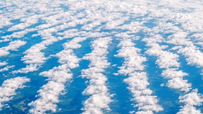
Cloud streets are impressive atmospheric phenomena characterized by long, parallel lines of cumulus clouds often seen in various regions of the world. They can stretch for miles across the sky, appearing like feathers ruffled by the wind. Understanding why these cloud formations occur involves delving into the specifics of meteorological conditions, atmospheric physics, and the influence of local geography.
One of the primary causes of cloud streets is the presence of a stable atmosphere that supports convection. Convection occurs when warm air rises into the atmosphere, and that process can be intensified by uneven heating of the Earth's surface. When sunlight heats the ground, the air above it warms up, creating thermal updrafts. The warm air rises and expands, eventually cooling off, which may lead to the formation of cumulus clouds. However, when these clouds group themselves into straight lines, it is often due to the presence of specific conditions that encourage this arrangement.
The Role of Wind Shear
Wind shear plays a pivotal role in the formation of cloud streets. Wind shear refers to the change in wind speed and direction at different altitudes. When there is a significant difference between surface winds and winds in the upper atmosphere, it can create conditions conducive to forming organized cloud streets. Typically, the lower-level winds need to converge, while upper-level winds should diverge. This arrangement allows for the sustained upward motion of air, promoting the creation of parallel lines of clouds.
As the rising columns of warm air reach cooler regions higher in the atmosphere, they condense to form clouds. If the shear in the wind is strong enough, the result is a series of aligned clouds that stand in sharp contrast to the clearer sections of the sky between them. The organized nature of cloud streets, therefore, can be attributed to the convergence of airflow along these lines, creating areas of uplift where the clouds form.
Geographic Influences
The location and geography also significantly affect whether cloud streets will form. Coastal regions are particularly prone to experiencing cloud streets, especially when cold maritime air meets warmer air from the land. This temperature gradient creates enough instability for convection currents to develop, leading to parallel cloud formations. Furthermore, geographically textured landscapes, such as mountain ranges, can influence local wind patterns and contribute to the formation of cloud streets.
For instance, as the wind rises over a mountain, it can create a downward flow on the other side, once again promoting straight line cloud formations if the air remains stable enough. Urban areas may also contribute to these formations, as heat generated by buildings and asphalt can enhance local lifting where cloud streets may occur.
Environmental Conditions
Other environmental factors, such as humidity and temperature, are crucial in cloud street formation. A moist atmosphere favors cloud development, while significant temperature differences can lead to the formation of these parallel cloud formations. Ultimately, it is a combination of these atmospheric elements that creates the ideal conditions for cloud streets to emerge.
Cloud streets often intersect with other meteorological phenomena and can offer scientists insights into larger climatic trends. For example, cloud streets are commonly associated with indoor tornadoes, organized thunderstorms, and frontal systems. Understanding these clouds can help improve forecasts and better comprehend weather patterns.
Examples and Occurrences
One notable instance of cloud streets occurs over the eastern United States, where prevalent phenomena such as lake-effect snow can contribute to the formation of these patterns. In regions like the Great Lakes, warm air blowing over colder lake waters can enhance convection, resulting in visible cloud streets forming over the entire vicinity.
Cloud streets are also observed over oceans, particularly in regions where differing water and air temperatures interact. The Gulf Stream, along the east coast of North America, is a prime example where these phenomena can be prominently witnessed. Tracking cloud streets visually aids meteorologists in understanding wind patterns and potential storm development.
The captivating spectacle of cloud streets, characterized by their straight lines and alignment, is a product of complex interactions between atmospheric conditions, geography, and environmental factors. The beauty of these cloud formations serves as a reminder of the intricate workings of our planet's atmosphere. Understanding cloud streets not only enhances our appreciation for weather phenomena but also emphasizes the importance of further studying the atmospheric sciences, as they continue to play a vital role in our climate system. As weather patterns evolve and change in response to global warming, observing and analyzing cloud streets will likely become even more critical in our ongoing pursuit of understanding the Earth's climate.