What Causes Cirrus Clouds to Spread
Discover the factors behind the formation and spreading of cirrus clouds in our atmosphere.

This image was created with the assistance of Freepik
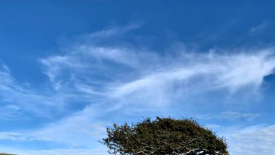
Cirrus clouds are high-altitude clouds characterized by their thin, wispy appearance. These clouds form at altitudes typically above 20,000 feet (6,000 meters) and are composed mainly of ice crystals due to the cold temperatures at such heights. Understanding the causes of cirrus clouds and their spreading involves examining various atmospheric processes and conditions.
Formation of Cirrus Clouds
The formation of cirrus clouds is primarily associated with the presence of rising air in the atmosphere. When warm, moist air ascends, it cools, and as it does so, the water vapor present in the air can condense into tiny water droplets or, due to the high altitude, crystallize into ice particles. These ice crystals then aggregate to form the delicate structures of cirrus clouds.
Temperature and Humidity
The temperature and humidity levels play a crucial role in the development of cirrus clouds. As air rises, it expands and cools, leading to a decrease in the amount of moisture it can hold. When the air reaches its dew point, the moisture condenses into ice crystals. In the presence of very low temperatures aloft, the ice crystals can persist and form the thin, feather-like appearance of cirrus clouds.
Role of Jet Streams
Jet streams are fast-flowing air currents found in the upper levels of the atmosphere, which can influence the development and spreading of cirrus clouds. These high-altitude winds can transport moist air to colder regions, aiding in the formation of cirrus clouds. Additionally, the winds associated with jet streams can cause the cirrus clouds to spread out over larger areas, creating extensive cloud cover that can lead to significant changes in local weather conditions.
Frontal Systems
Frontal systems, particularly warm fronts, are also significant in the creation of cirrus clouds. As a warm front approaches, the warm air is forced to rise over cooler air, leading to the formation of cirrus clouds ahead of the front. This process can result in the extensive spreading of cirrus clouds, often seen in advance of precipitation associated with the frontal system.
Convergence and Divergence
Air convergence and divergence within the atmosphere also contribute to the spreading of cirrus clouds. Convergence occurs when air flows toward a common point, leading to upward motion and the potential for cloud formation. When this rising air cools, it may form cirrus clouds that can spread as the air continues to diverge at higher altitudes. Conversely, areas of divergence can allow for the rapid expansion of existing cirrus clouds, contributing to their widespread distribution.
Mid-Latitude Cyclones
Mid-latitude cyclones, which are large-scale low-pressure systems, are another important factor in the development and dissemination of cirrus clouds. As these systems move through a region, they can create unstable air masses, often resulting in the uplift of moist air. The interaction of different air masses can enhance the formation of cirrus clouds, particularly ahead of the low-pressure center, where the clouds can spread extensively.
Impact of Climate Change
Climate change may also affect the frequency and distribution of cirrus clouds. As global temperatures rise, the dynamics of atmospheric circulation may change, potentially altering how and when cirrus clouds form and spread. Increased humidity in a warming atmosphere can lead to more prevalent cirrus cloud formation, influencing radiative forcing and impacting the Earth's climate system in various ways.


