The Science Behind Lake Effect Snow and Endless Local Forecasts
Explore the science of lake effect snow and how meteorologists provide detailed local forecasts for these intense weather events.
Lake effect snow is a fascinating meteorological phenomenon that often results in heavy snowfall in regions surrounding large lakes, particularly in the Great Lakes area of North America. This localized snow event can transform mundane winter days into intense snowstorms, causing both challenges and awe among residents and meteorologists alike. Understanding the science behind lake effect snow involves dissecting atmospheric conditions, lake temperatures, geographical factors, and the way weather forecasts are generated and continually updated to keep the public informed.
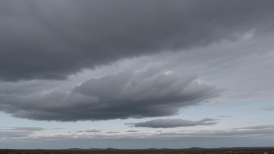
At its core, lake effect snow forms when cold, dry air masses move over warmer bodies of water. The temperature difference between the significantly warmer water surface and the frigid air above creates instability in the atmosphere. As the cold air passes above the warmer lake surface, it picks up moisture and heat, which triggers convection processes. This moisture-laden air then rises, cools, and condenses into clouds dense with water droplets and ice crystals. When these clouds move onto land, the moisture is released as snow.
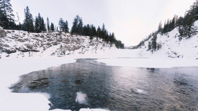
The Great Lakes, consisting of Lakes Superior, Michigan, Huron, Erie, and Ontario, are ideally sized and located to produce substantial lake effect snow events. Their expansive water surfaces provide vast amounts of heat and moisture, especially in late fall and early winter when lake waters are relatively warm compared to the incoming cold air masses. This dynamic leads to some of the heaviest snowfall recorded in the United States and Canada. Regions downwind of these lakes, such as Buffalo, New York, and the Tug Hill Plateau, often experience severe lake effect snowstorms resulting in significant snow accumulations within short time frames.
One of the key factors influencing lake effect snow intensity is the temperature difference between the lake surface and the air above. Meteorologists generally consider a temperature difference of at least 13°C (23°F) across the lowest 1,000 meters of the atmosphere to be critical for lake effect snow formation. Larger temperature contrasts enhance atmospheric instability, leading to stronger updrafts and more intense snowstorms.
Wind direction and speed also play major roles. For lake effect snow to occur, winds must blow consistently over the lake, typically from the northwest or southwest depending on the specific lake. This steady wind allows the air to acquire substantial moisture while traversing the lake. The length of the lake over which the air travels, known as the fetch, impacts how much moisture the air can absorb. Longer fetches generally produce heavier lake effect snowfalls as more moisture accumulates.
As the air crosses the lake’s surface, heat and moisture transfer occur. The water’s heat warms the lowest layers of the atmosphere, promoting evaporation. This evaporation injects water vapor into the cold air, increasing humidity and buoyancy. Once the air reaches the leeward shore, it is often forced to ascend due to terrain elevations or abrupt land features, further cooling the air and causing condensation of the moisture into snow. This orographic lift effect can amplify snowfall totals dramatically, especially in hilly or mountainous areas downwind of the lakes.
The timing within the year is crucial. Early in winter, the Great Lakes are unfrozen and retain much of their autumn warmth, creating ideal conditions for lake effect snow. As winter progresses, ice forms on the lakes reducing open water, therefore limiting the moisture available for snow production. This natural feedback tends to curtail lake effect snow events as the season advances. However, intermittent thaws and ice breaks can reignite lake effect snowfall temporarily.
Lake effect snow is often highly localized and can vary dramatically over short distances. One town might be buried under multiple feet of snow while another nearby area receives only a dusting. This variability arises from shifts in wind direction altering the snowbands, lake surface temperature variations, and local geographic features that influence air flow and precipitation. Meteorologists struggle with these complexities when attempting to deliver accurate local forecasts.
Local weather forecasting for lake effect snow uses a blend of observational data, satellite imagery, radar, and numerical weather prediction models. Observations from weather stations measuring temperature, wind, humidity, and snow depth are vital in tracking ongoing conditions. Satellites provide imagery of cloud formations and lake surface temperatures, while radar monitors snowfall intensity and movement. These data streams feed into numerical models that simulate atmospheric conditions at high resolution.
Numerical weather prediction involves solving complex equations representing physical processes such as thermodynamics, fluid dynamics, and radiation to forecast atmospheric conditions. For lake effect snow, meteorologists use mesoscale models with grid spacing as fine as 1-3 kilometers to capture the small-scale features of lake and land interactions. These models help predict the location, timing, and intensity of snowbands down to city blocks in some cases.
Despite advances, forecasting lake effect snow remains challenging due to the rapid development and movement of snowbands. These bands can form suddenly, intensify quickly, and dissipate just as fast, requiring continual model updates and real-time data assimilation. Forecasters often issue frequent local updates and warnings to inform populations of changing conditions and potential hazards like road closures and power outages.
Communication with the public during lake effect snow events is key for safety and preparedness. Local National Weather Service offices and media outlets keep watchful eyes on evolving weather patterns and provide detailed forecasts that include snowfall amounts, duration, and expected impacts. Social media platforms allow meteorologists to share real-time updates and engage directly with the community, enhancing situational awareness.
Technological improvements have also bolstered forecasting accuracy. Doppler radar technology better quantifies precipitation rates and can discern snowbands embedded within larger storm systems. Enhanced satellite sensors track lake ice growth and surface temperature fluctuations, important factors controlling lake effect snow potential. Supercomputers enable more frequent and detailed simulations of atmospheric phenomena at the scale required to represent lake effect processes.
Understanding lake effect snow and its forecasting has important implications beyond immediate weather concerns. Heavy snowfall impacts infrastructure, transportation, emergency services, and local economies. Accurate and timely forecasts enable municipalities to allocate snow removal resources efficiently, prepare emergency responders, and reduce accidents. This knowledge also supports climatological studies predicting how lake effect snow patterns might evolve with changing climate scenarios.
Climate change poses complex questions about the future of lake effect snow. On one hand, warmer air temperatures might reduce the frequency of very cold air masses needed to trigger lake effect events. On the other hand, warmer lake water temperatures and delayed ice formation could extend the window during which lake effect snow can develop. This dynamic interplay means some regions might see more intense or prolonged lake effect snowfalls, while others experience declines.
Research continues to refine the understanding of lake effect snow mechanisms and improve forecasting techniques. Scientists deploy weather balloons, drones, and specialized instrument arrays on and around lakes to gather detailed atmospheric data. These observations feed into model development efforts aiming to capture microphysical snow formation, boundary layer processes, and the effects of lake ice and temperature heterogeneity.
Education and outreach about lake effect snow science also play a vital role in hazard awareness. Schools, community groups, and meteorological agencies collaborate to disseminate information on how lake effect snow forms, safety tips for winter storms, and the importance of weather forecasts. These efforts help residents make informed decisions during severe winter weather and foster a deeper appreciation of the natural phenomena shaping their local environment.
In summary, lake effect snow is a remarkable product of the interaction between cold air masses and large unfrozen lakes, influenced by temperature differentials, wind patterns, lake size, and geography. Its highly localized and variable nature makes prediction complex but critical. Thanks to advances in meteorological science, technology, and communication, communities can better anticipate and respond to these intense snow events, improving public safety and resilience during harsh winter seasons.
Continued research and monitoring will unveil further details about lake effect snow, helping refine our understanding of its processes and potential changes in a warming world. Meanwhile, the spectacle of snow bands streaming off lakes and dropping heavy snowflakes on willing landscapes remains a captivating demonstration of nature’s intricate atmospheric machinery at work.