The Meteorology Behind Sudden Downpours
Explore the meteorological processes that cause sudden downpours and learn how weather patterns trigger intense rain events.
Sudden downpours are a common and often disruptive weather event that can lead to flash flooding, traffic hazards, and even property damage. Understanding the meteorological mechanisms behind these abrupt bursts of intense rainfall helps meteorologists improve forecasting and provides valuable insights for emergency preparedness. This article delves into the science of sudden downpours, exploring atmospheric conditions, cloud formation, and key weather phenomena that contribute to these intense rain events.
What Defines a Sudden Downpour?
A sudden downpour, also known as a rain shower or heavy rain shower, is characterized by a rapid onset of intense precipitation that usually lasts from a few minutes to an hour. Unlike steady rainfall, which can persist for hours, sudden downpours have a sharp beginning and often occur in localized areas. Their intensity can vary from moderate to torrential, sometimes dropping several millimeters of rain within a short span of time. These events are typically associated with convective processes in the atmosphere, where vertical motions rapidly lift moist air leading to quick condensation and precipitation release.
The Role of Atmospheric Moisture
Atmospheric moisture is a fundamental ingredient for any precipitation, including sudden downpours. Water vapor enters the atmosphere primarily by evaporation from oceans, lakes, rivers, and transpiration from plants. When moist air rises and cools, the water vapor condenses into liquid droplets or ice crystals, forming clouds. The amount of moisture available is often quantified by humidity and dew point temperature. Environments with high humidity and elevated dew points favor cloud formation and increase the likelihood of precipitation events.
Convective Processes and Instability
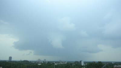
The key driver behind sudden downpours is atmospheric instability combined with convection. Instability occurs when warm, moist air near the surface is overlain by cooler air aloft. This temperature difference creates a buoyant force that causes the warm air to rise rapidly. This rising motion is known as convection. Convective clouds, particularly cumulonimbus clouds, are often responsible for heavy showers and thunderstorms.
As the warm air ascends, it cools and water vapor condenses into cloud droplets. If the upward motion is strong enough, these droplets can grow rapidly and coalesce to form larger raindrops. The continual lifting can fuel deep cloud development extending high into the troposphere, allowing for significant precipitation amounts in a short period.
The Formation of Cumulonimbus Clouds
Cumulonimbus clouds are towering giants in the sky often associated with sudden downpours. They form through strong convection driven by surface heating combined with high humidity. The vertical growth of cumulonimbus clouds can reach heights of 10 to 15 kilometers or more, penetrating the tropopause.
Within these clouds, powerful updrafts lift warm, moist air, while downdrafts carry precipitation downward. The presence of both updrafts and downdrafts creates dynamic air circulation that facilitates the rapid buildup and release of rain. The sudden onset of precipitation occurs when raindrops or ice particles become too heavy to be sustained by the updrafts and fall rapidly toward the surface.
Triggers for Convection
Several factors can initiate convection leading to sudden downpours:
- Surface Heating: Intense solar heating can warm the Earth's surface, causing the adjacent air to rise.
- Topography: Mountains and hills can force air upward, enhancing convection through orographic lifting.
- Cold Fronts: The passage of a cold front can lift warm, moist air ahead of it, triggering thunderstorms.
- Sea Breezes: Coastal regions may experience convection as the differential heating between land and sea causes air to rise.
- Outflow Boundaries: Cool air from a thunderstorm can spread out at the surface and lift warm air, sparking new convection.
The Role of Atmospheric Layers and Temperature Profiles
The vertical temperature profile of the atmosphere influences the development of convection and sudden downpours. Meteorologists refer to the concept of lapse rate—the rate at which temperature decreases with height. When the environmental lapse rate is greater than the moist adiabatic lapse rate, the atmosphere is considered unstable, which promotes vertical motion.
Temperature inversions, where temperature increases with height, can suppress convection by creating a cap that prevents warm air from rising. However, if the cap is broken by surface heating or lifting mechanisms, explosive development of cumulonimbus clouds and intense downpours can occur.
Microphysics of Precipitation Formation
Within storm clouds, microphysical processes govern how water droplets and ice particles grow and eventually fall as precipitation:
- Collision and Coalescence: Smaller droplets collide and merge to form larger drops capable of falling as rain.
- Bergeron Process: In mixed-phase clouds, ice crystals grow at the expense of supercooled water droplets, enhancing precipitation formation.
- Freezing and Melting: Raindrops may freeze and melt repeatedly, influencing the size and type of precipitation reaching the ground.
Thunderstorms and Sudden Downpours
Thunderstorms, which are convective storms that produce lightning and thunder, are frequently linked to sudden downpours. These storms often contain intense updrafts exceeding 10 meters per second and contain large quantities of water and ice. The downdrafts in thunderstorms bring cold rain-cooled air toward the surface, sometimes resulting in heavy rain falling suddenly.
Microbursts, strong downward winds produced by thunderstorms, can also cause rapid onset of heavy rainfall and wind damage. These downbursts typically last a few minutes but can release very intense precipitation localized in small areas.
Mesoscale Convective Systems
On larger scales, clusters of convective storms may organize into mesoscale convective systems (MCS). These systems can cover hundreds of kilometers and last several hours, producing widespread and sometimes sudden heavy rain. The interaction of multiple storm cells within the system can sustain convection and precipitation for extended periods. Sudden downpours within an MCS can occur as individual convective cells intensify and then move through an area.
The Influence of Humidity and Atmospheric Pressure
High humidity ensures ample moisture supply for cloud and precipitation formation. Atmospheric pressure patterns influence the distribution and movement of air masses. Low-pressure systems are generally associated with rising air and favorable conditions for precipitation. Conversely, high-pressure systems tend to bring sinking air, suppressing cloud formation and rain.
Role of Wind Shear
Wind shear, the change of wind speed or direction with height, can impact the structure and longevity of convective storms. Moderate wind shear can organize thunderstorms into more robust systems capable of producing prolonged downpours. Excessive shear tends to disrupt storms, while very low shear limits storm organization.
Short-Term Weather Prediction Challenges
Forecasting sudden downpours remains a challenging aspect of meteorology due to their localized and transient nature. Numerical weather prediction models often struggle to resolve small-scale convective activity accurately. High-resolution regional models and real-time observations like radar help meteorologists anticipate the development of abrupt showers but uncertainty remains.
Techniques such as nowcasting use radar and satellite data to provide short-term forecasts of precipitation onset and intensity, crucial for timely warnings during sudden downpours. Improvements in data assimilation and computing power continue to enhance predictive capability.
Environmental and Societal Impacts
Sudden downpours can cause flash flooding, soil erosion, and damage to infrastructure. Urban areas are particularly vulnerable due to impervious surfaces that increase runoff. These events can disrupt transportation, agriculture, and daily life. Understanding the meteorology behind sudden downpours aids in planning and mitigation efforts to reduce risk.
Examples of Sudden Downpour Events
Notable sudden downpours include summer thunderstorms in tropical regions like Florida or the Indian monsoon’s intense rain bursts. In midlatitude locations, cold front passages often bring sudden showers. Flash floods in urban centers such as Houston or Mumbai frequently result from these intense rain events.
Influence of Climate Change
Climate change is impacting precipitation patterns worldwide. Warmer air holds more moisture, potentially increasing the frequency and intensity of heavy rain showers. This trend may lead to more frequent sudden downpours, necessitating improved infrastructure and forecasting techniques to handle increased risk.
Overall, the meteorology behind sudden downpours involves a complex interplay of moisture availability, atmospheric instability, convection, and large-scale weather patterns. Continuous research and technological advances improve our understanding and ability to predict these sudden but impactful rain events.