How Weather Satellites See Storms Before They Start
Discover how weather satellites forecast storms by monitoring atmospheric conditions in advance.

This image was created with the assistance of Freepik
Weather satellites have revolutionized meteorology and storm prediction, enabling us to see storms forming before they wreak havoc. By using advanced technology, these satellites provide critical data that helps meteorologists forecast severe weather events. This article delves into how weather satellites observe and analyze storm development, allowing scientists to predict when and where storms will occur.
The Role of Weather Satellites
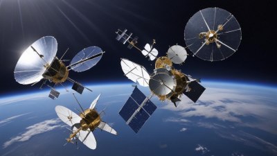
Weather satellites are integral to modern meteorology. They orbit our planet at various altitudes, capturing images and data to track weather patterns. These satellites can monitor clouds, temperature fluctuations, humidity levels, and other atmospheric variables. By providing a comprehensive view of the Earth's atmosphere, they help forecasters identify potential storm systems.
Types of Weather Satellites
There are two primary categories of weather satellites: geostationary and polar-orbiting satellites. Geostationary satellites are positioned at an altitude of about 22,236 miles above the equator, allowing them to continuously monitor the same area of the Earth. They provide real-time data, which is crucial for tracking storms as they develop. Polar-orbiting satellites, on the other hand, travel between the North and South Poles, covering the entire Earth as it rotates. These satellites provide detailed imagery at regular intervals, making them useful for long-term weather predictions.
Observing Cloud Formation
One of the critical functions of weather satellites is observing cloud formation. By capturing images in different wavelengths of light, satellites can detect variations in moisture and temperature within cloud systems. Infrared sensors, for instance, can identify cold cloud tops associated with severe storms, while visible light sensors give a clearer picture of the cloud's structure. This information helps meteorologists assess storm strength and track its progression.
Data Gathering and Processing
Weather satellites gather a wealth of data that meteorologists use to create forecasts. This data includes temperature, humidity, wind speed, and precipitation levels. Once collected, the information is sent back to Earth, where it undergoes processing in supercomputers. Advanced algorithms analyze the data and generate predictive models, allowing meteorologists to forecast when and where storms will develop. This predictive capability is essential for issuing timely warnings to minimize the impact of severe weather events.
Tracking Storms in Real-Time
One of the most significant advantages of weather satellites is the ability to track storms in real time. As storms develop, satellites continuously monitor their movement and intensity. This information is crucial for issuing weather alerts and warnings to communities at risk. Meteorologists use satellite data to track hurricanes, tornadoes, and severe thunderstorms, providing updates on their expected paths and potential impacts. This real-time monitoring can be a lifesaver, giving people the crucial time needed to prepare for a storm’s arrival.
Predicting Severe Weather Events
Weather satellites excel at predicting severe weather events. By analyzing infrared and microwave data, forecasters can determine the likelihood of heavy rain, thunderstorms, and snowfall. These predictions are vital for industries such as agriculture, transportation, and emergency management. They help farmers plan for planting and harvesting, guide airlines in scheduling flights, and assist authorities in preparing for possible evacuations. Satellite-based predictions have greatly improved our ability to respond to severe weather threats.
The Future of Weather Satellite Technology
The field of meteorology is constantly evolving, and so is the technology behind weather satellites. Recent advancements include the deployment of next-generation satellites, which are equipped with improved sensors and data processing capabilities. These satellites can provide higher resolution images and more accurate weather predictions. Additionally, researchers are working on incorporating artificial intelligence and machine learning into weather forecasting. This integration will enhance our ability to analyze vast amounts of satellite data, leading to more precise forecasts and earlier warnings for severe weather events.
In conclusion, weather satellites play a pivotal role in our understanding of atmospheric conditions and storm prediction. By monitoring cloud formation, gathering data, and tracking storms in real-time, they provide invaluable insights that help us prepare for severe weather. As technology advances, weather satellites will become even more powerful tools in combating the destructive impacts of storms. Our ability to see storms before they start will continue to improve, contributing to greater safety and preparedness for communities around the world.


