How Weather Satellites Predict Storms From Space
Explore how weather satellites monitor and predict storms by capturing data from space to improve forecasting accuracy and safety.
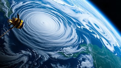
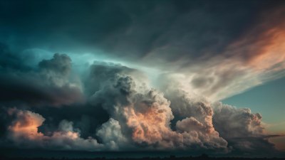
Image created with Flux Schnell
Weather satellites play a crucial role in monitoring and predicting storms from space, providing vital data that enables meteorologists to forecast severe weather events accurately and in a timely manner. These advanced satellites orbit the Earth and continuously collect valuable information about the atmosphere, oceans, and land surfaces, offering a global perspective that ground-based systems alone cannot achieve.
At the heart of storm prediction lies the ability of weather satellites to detect early signs of atmospheric disturbances such as cyclones, hurricanes, tornadoes, and thunderstorms. By observing cloud formations, temperature changes, wind patterns, and humidity levels, satellites offer real-time data that can indicate the development, progression, and potential impact of weather systems.
Types of Weather Satellites
There are primarily two types of weather satellites: geostationary satellites and polar-orbiting satellites. Geostationary satellites orbit approximately 35,786 kilometers above the Earth's equator and remain fixed over a single location. This positioning allows them to provide continuous monitoring of weather patterns over a specific area. On the other hand, polar-orbiting satellites move in a north-south orbit, passing over the poles and circling the globe approximately 14 times per day.
Each satellite type offers unique advantages for storm prediction. Geostationary satellites provide rapid updates, typically every 5 to 15 minutes, which is invaluable for tracking fast-changing storm systems. Polar-orbiting satellites offer global coverage and detailed vertical profiles of the atmosphere, helping create comprehensive models that forecast storm behavior.
Satellite Instruments Used for Storm Monitoring
Weather satellites are equipped with sophisticated instruments designed to measure various atmospheric parameters critical to storm prediction. These include visible and infrared cameras, microwave sensors, radar instruments, and sounders.
Visible and infrared sensors capture images that show cloud cover, storm structure, and temperature differences. Infrared imaging is particularly useful during nighttime when visible light is not available. Microwave sensors penetrate clouds and precipitation, allowing scientists to observe rain intensity and water vapor content. Radar instruments onboard some satellites can directly measure storm precipitation rates and wind speeds by analyzing the reflected signals.
Sounders provide vertical profiles of temperature, humidity, and atmospheric pressure by detecting emitted radiation at different wavelengths. This vertical information is essential to understanding the atmosphere's stability and potential for storm development.
How Satellites Detect Storm Formation
The first sign of storm formation often appears as changes in cloud patterns detected by satellite sensors. Weather satellites monitor factors such as rapid cloud growth, increased moisture content, and the organization of clouds into spiral bands, all of which are indicative of developing tropical cyclones or severe thunderstorms.
Environmental parameters like sea surface temperature can also be measured by satellites. Warm ocean waters fuel tropical storm development, so detecting areas with rising surface temperatures is a critical step in identifying regions prone to cyclones. Satellite data helps meteorologists track these temperature changes and anticipate the emergence of storms.
Tracking Storm Movement and Intensity
As a storm intensifies, satellite observations provide continuous information on movement, size, and strength. Using satellite imagery, meteorologists can follow the trajectory of storms, estimate wind speeds, pressure drops, and rainfall intensity. This data is combined with ground-based observations and computer models to forecast the storm's path and potential impact areas accurately.
For hurricanes and cyclones, satellites track the eye of the storm, which is a calm area at the center, surrounded by the most intense weather conditions. The size and temperature of the eye provide clues about the storm's strength. For example, a well-defined eye generally indicates a mature and powerful hurricane.
Role of Computer Models and Data Integration
The raw data collected by weather satellites is processed and integrated into advanced computer models that simulate atmospheric conditions. These numerical weather prediction models use the satellite data to improve their initial conditions, which is critical to producing reliable forecasts.
By assimilating satellite observations with surface measurements, radar data, and balloon soundings, these models predict the future state of the atmosphere. They simulate how storms will develop, where they will move, and how intense they might become. Continuous updates from satellites help refine the predictions and extend the lead time for warnings.
Operational Meteorology and Early Warning Systems
Weather satellites support operational meteorology, enabling timely decisions to protect lives and property. For example, when satellites detect a storm forming or intensifying, meteorological agencies issue watches and warnings to affected regions. This early warning system allows communities to prepare by evacuating vulnerable areas, reinforcing infrastructure, and activating emergency response plans.
Satellite data also aids in disaster management during and after storms by providing damage assessments through high-resolution imagery. This helps relief agencies prioritize areas in need and coordinate resources efficiently.
International Collaboration and Satellite Networks
Storm prediction relies on a network of international satellite systems that share data and resources. Organizations such as the National Oceanic and Atmospheric Administration (NOAA), the European Organisation for the Exploitation of Meteorological Satellites (EUMETSAT), and Japan Meteorological Agency (JMA) operate satellites that contribute to global weather monitoring.
Data sharing agreements and coordinated observation schedules ensure continuous, comprehensive coverage of the Earth's atmosphere. This collaboration enhances the accuracy and reliability of storm forecasts worldwide.
Recent Advances in Satellite Technology
Recent advances in satellite technology have significantly improved storm prediction capabilities. Innovations such as higher resolution sensors, faster data processing, and the deployment of small satellite constellations provide more timely and detailed observations.
New satellites also carry advanced instruments capable of measuring properties like atmospheric composition and lightning activity, which add valuable information for understanding storm dynamics. Enhanced data assimilation techniques allow models to make better use of the rich datasets, reducing forecast errors and extending the prediction horizon.
Challenges and Limitations
Despite their effectiveness, weather satellites face challenges and limitations. Cloud interference, sensor calibration issues, and data transmission delays can affect the quality and timeliness of observations. Additionally, interpreting satellite data requires expertise and advanced algorithms to accurately distinguish between different types of weather phenomena.
Predicting the exact intensity and rapid changes in storms remains complex due to the chaotic nature of weather systems. Thus, satellite data is combined with other observational methods and continuously refined through research and development.
The Future of Storm Prediction From Space
Looking ahead, the future of storm prediction lies in enhancing satellite capabilities through new generations of spacecraft equipped with cutting-edge sensors and artificial intelligence-driven data analysis. The integration of satellite data with emerging technologies such as drones, ground sensors, and supercomputers promises to deliver even more precise and timely forecasts.
As climate change increases the frequency and severity of storms, advanced satellite monitoring will be essential to improve preparedness and resilience globally. Continuous investment in space-based weather observation is critical for safeguarding communities and minimizing the devastating impacts of severe storms.