How Surface Heating Fuels Afternoon Thunderstorms
Explore how surface heating triggers and sustains afternoon thunderstorms through atmospheric processes and weather dynamics.
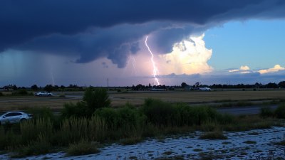
Afternoon thunderstorms are a common meteorological phenomenon, particularly in the warm months and regions with significant solar heating. A key driver behind these storms is the heating of the Earth's surface, which initiates a series of atmospheric processes that can culminate in the formation of thunderclouds and precipitation. Understanding how surface heating fuels afternoon thunderstorms involves examining the complex interplay between solar radiation, surface conditions, atmospheric stability, and moisture availability.
Solar Radiation and Surface Warming
During daylight hours, the sun's radiation reaches the Earth's surface, transferring energy in the form of shortwave radiation. The amount of solar energy absorbed by the surface depends on factors such as the angle of the sun, the reflectivity (albedo) of the ground, and cloud cover. Darker surfaces like asphalt, dense vegetation, and bare soil absorb more heat, while lighter surfaces such as sand or snow reflect more solar radiation.
As the surface warms, it transfers heat to the overlying air through conduction and convection. The increase in temperature near the ground warms the air in contact with it, causing it to become less dense and more buoyant. This warming process is fundamental for initiating the upward movement of air parcels that can lead to thunderstorm development.
Instability and Convective Processes
The concept of atmospheric instability plays a central role in thunderstorm formation. Instability occurs when a parcel of air, if lifted, remains warmer and less dense than its surrounding environment, allowing it to continue rising freely. Surface heating can destabilize the lower atmosphere by increasing the temperature at the surface while upper layers remain relatively cooler.
The sun-warmed air near the surface begins to rise due to buoyancy, forming thermals or updrafts. As these warm air parcels ascend, they expand and cool at the dry adiabatic lapse rate (approximately 10 degrees Celsius per kilometer). If the atmosphere is conditionally unstable, these rising parcels encounter the lifting condensation level (LCL), where moisture condenses into visible water droplets, creating cumulus clouds.
Moisture Availability and Humidity
Surface heating alone is insufficient to generate thunderstorms; adequate moisture near the surface is also crucial. This moisture typically originates from sources such as nearby bodies of water, soil evaporation, transpiration from vegetation, or moist air masses. High relative humidity levels mean the air is closer to saturation, making it easier for clouds to form once air parcels are lifted.
As the warm, moist air rises and cools, water vapor condenses into liquid droplets, releasing latent heat. This heat release further warms the air parcel relative to its surroundings, enhancing buoyancy and reinforcing the upward motion. The continual rise of moist air amplifies convection, promoting the development of towering cumulonimbus clouds associated with thunderstorm activity.
The Role of Surface Conditions
Surface conditions can significantly influence afternoon thunderstorm development. Urban areas, with extensive pavement and buildings, often experience an "urban heat island" effect, where temperatures are notably higher than surrounding rural areas. This enhanced heating can increase local instability and promote thunderstorm formation over or downwind of cities.
Similarly, variations in land cover, such as forests, grasslands, or water bodies, affect heating rates and moisture availability. For example, forested areas may provide more transpiration, increasing humidity, while open fields may heat more rapidly but with less moisture contribution. The interaction between these surface characteristics determines local temperature and humidity gradients, influencing where thunderstorms are most likely to initiate.
Time of Day and the Peak of Thunderstorm Activity
Afternoon thunderstorms most commonly occur in the mid to late afternoon because this is typically when surface temperatures peak. Solar radiation accumulates throughout the morning and early afternoon, progressively heating the ground and the air just above it. By around 3 to 5 p.m., the greatest instability and buoyancy often exist, providing optimal conditions for convection and thunderstorm development.
After sunset, the absence of solar radiation causes surface temperatures to drop, stabilizing the atmosphere and reducing convection. Consequently, thunderstorm activity tends to decrease significantly during the evening and overnight hours unless supported by other meteorological processes such as frontal systems or upper-level disturbances.
Vertical Wind Shear and Storm Organization
While surface heating initiates convection, the presence and characteristics of vertical wind shear can influence the organization and severity of thunderstorms. Wind shear refers to the change in wind speed or direction with height. Moderate shear promotes updraft tilt and storm longevity, allowing thunderstorms to become more organized and sometimes severe.
In environments with strong surface heating and sufficient moisture, weak wind shear may lead to isolated, short-lived pulses of thunderstorm activity often termed "pulse storms." Conversely, stronger shear can support the development of multicellular clusters or supercells, which are capable of producing more intense weather phenomena such as hail, strong winds, or tornadoes.
Thermodynamic Profiles and Convective Parameters
Meteorologists analyze thermodynamic profiles obtained from weather balloon soundings to assess the potential for afternoon thunderstorms. Key parameters include Convective Available Potential Energy (CAPE), which quantifies the energy available for convection, and Lifted Index (LI), indicating the stability of the atmosphere.
High CAPE values often correspond with strong surface heating and abundant moisture, signaling a robust potential for thunderstorms. A negative Lifted Index suggests that lifted parcels of air are warmer than the environment, favoring thunderstorm development. Monitoring these indices throughout the day helps forecasters predict when and where surface heating might initiate afternoon convection.
Orographic Effects on Surface Heating and Storm Formation
In regions with mountainous terrain, surface heating can be uneven due to varying slopes and aspects, leading to localized areas of intensified warming. South-facing slopes in the northern hemisphere receive more solar radiation and heat faster, stimulating upslope winds and enhancing localized convection.
Orographic lifting—air forced to rise over terrain—combined with surface heating can further intensify thunderstorm formation along mountain ridges and valleys. This complex interaction often results in afternoon thunderstorms preferentially developing in mountainous regions, with terrain influences modifying timing and intensity.
Surface Heating and Boundary Layer Development
The depth and characteristics of the atmospheric boundary layer are shaped significantly by surface heating. The boundary layer is the lowest part of the atmosphere influenced directly by the surface, where temperature, moisture, and wind conditions can change rapidly.
Strong daytime heating causes the boundary layer to deepen, promoting turbulent mixing and vertical transport of heat and moisture. This deepening boundary layer effectively serves as the incubator for convective storms, supporting vigorous updrafts that can pierce through the inversion layer that may cap convection earlier in the day.
Sea Breezes and Surface Heating Interactions
In coastal regions, surface heating often interacts with sea breeze circulations to enhance afternoon thunderstorm development. Land heats more efficiently than water, causing air over the land to rise and creating a pressure differential that drives cooler, moist air inland from the sea.
The convergence zone formed at the interface between sea breeze and storm outflows provides additional lift for air parcels heated at the surface. This convergence acts as a focal point for convection initiation, leading to organized clusters of thunderstorms typically beginning in the mid-afternoon along coastlines.
Surface Heating Versus Large-Scale Weather Patterns
While surface heating is a vital ingredient for afternoon thunderstorm formation, it must be considered within the context of the prevailing synoptic weather patterns. Large-scale features such as cold fronts, upper-level troughs, or low-pressure systems can modify atmospheric stability, moisture profiles, and wind patterns.
For instance, a cold front advancing through a heated air mass can dramatically increase lift, triggering widespread thunderstorm outbreaks beyond the isolated convective cells typically fueled by surface heating alone. Similarly, subsidence from high-pressure systems can suppress convection despite strong solar heating.
The Impact of Surface Heating on Thunderstorm Intensity
The vigor of surface heating influences not only thunderstorm initiation but also their intensity and longevity. Stronger heating leads to larger temperature gradients and greater buoyancy, resulting in more powerful updrafts. These robust updrafts can support the development of taller cumulonimbus towers, enhancing precipitation rates and the potential for severe weather.
Additionally, intense surface heating elevates moisture fluxes from evaporation, feeding thunderstorms with sustained fuel, prolonging their lifespan, and sometimes causing multiple thunderstorm cells to merge into more complex storm systems.
Surface Heating and Hail Formation
Hail production within thunderstorms is intricately linked to the strength of the updrafts, which are influenced by surface heating. Potent upward motions can keep hailstones suspended longer in the cold upper portions of the cloud, allowing them to grow larger before they fall to the ground.
Regions that experience intense afternoon heating thus have a greater likelihood of hail occurrences during thunderstorm episodes, especially when combined with appropriate moisture and wind shear conditions.
Human Activities and Modifications of Surface Heating
Human-induced changes to land surfaces can alter local heating patterns and potentially affect thunderstorm development. Urbanization replaces natural vegetation with heat-absorbing materials, increasing surface temperatures and creating urban heat islands. Agriculture, deforestation, and irrigation modify soil moisture content and surface albedo, influencing surface energy budgets.
Such modifications can locally amplify or suppress convection, impacting the frequency, timing, and location of afternoon thunderstorms. Understanding these anthropogenic effects is critical for urban planning and managing weather-related hazards.
Predicting Afternoon Thunderstorms Using Surface Heating Data
Weather forecasting models incorporate surface temperature measurements and projections to estimate the likelihood of afternoon thunderstorms. Satellites provide data on surface thermal properties and vegetation health, while ground-based sensors monitor soil moisture and temperature.
By inputting this information into numerical weather models that simulate atmospheric physics and thermodynamics, forecasters can predict thunderstorm initiation times and locations with higher precision, aiding in early warnings and public safety measures.
Case Study: Surface Heating and Thunderstorms in the Midwest USA
The central United States frequently experiences strong surface heating during summer months, creating ideal conditions for widespread afternoon thunderstorms. Heat absorbed by extensive farmland and urban centers raises low-level temperatures, while moisture advected from the Gulf of Mexico provides ample humidity. Heat-induced surface instability often culminates in numerous convective storms by mid-afternoon.
These storms contribute significantly to summer precipitation but can also bring severe weather. Meteorologists closely monitor surface temperature trends, soil moisture, and atmospheric soundings during this time to anticipate storm formation and issue timely alerts.
Surface Heating's Role in Tropical Thunderstorms
In tropical climates, intense and consistent solar heating maintains high surface temperatures year-round. The combination of abundant moisture and surface heating leads to frequent and often intense afternoon thunderstorms, which help regulate the tropical energy balance.
Tropical thunderstorms play a critical role in vertical heat and moisture transport, often serving as building blocks for larger-scale weather systems like tropical cyclones. The daily cycle of surface heating creates a rhythmic pattern of convective activity essential to tropical climate dynamics.
Surface Heating and Climate Change Considerations
As global temperatures rise due to climate change, surface heating patterns are also shifting. Increased surface temperatures can lead to stronger convective activity and potentially more frequent or intense afternoon thunderstorms in some regions. However, changes in moisture availability and atmospheric circulation may also alter thunderstorm dynamics in complex ways.
Research continues to explore how these factors will interact under warming scenarios to better predict future thunderstorm behavior and inform climate adaptation strategies.
Overall, surface heating is a foundational driver of afternoon thunderstorms, facilitating the thermal and moisture conditions necessary for convective storm development. Its interaction with atmospheric stability, moisture content, wind shear, surface features, and larger-scale weather systems shapes when and where thunderstorms arise, how severe they become, and their impact on the environment and society.