How Local Geography Alters Rainfall Patterns
Explore how various geographical features influence local rainfall patterns and their impacts on climate and ecosystems.
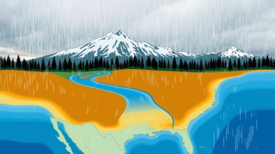
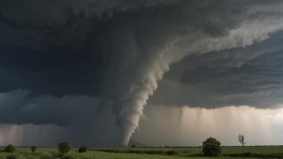
Image created with Flux Schnell
Rainfall, a crucial component of the Earth's hydrological cycle, is influenced by multiple factors, with local geography playing a vital role in shaping its patterns. Variations in landscape, such as mountains, valleys, coastlines, and urban areas, cause differences in amount, intensity, frequency, and distribution of precipitation. Understanding how local geographic features modify rainfall patterns helps meteorologists forecast weather, manage water resources, and predict ecological changes.
At the core of geographic impact on rainfall is the concept of orographic lift. Mountains act as barriers to prevailing winds, forcing moist air masses to rise. As the air ascends, it cools adiabatically, condensing water vapor into cloud droplets and eventually producing precipitation, often on the windward side. This phenomenon causes higher rainfall on mountain slopes facing moist winds, while the leeward side, shielded from direct airflow, experiences dry conditions, known as rain shadows. The Cascade Range in the Pacific Northwest exemplifies this, with lush west-facing slopes and arid eastern valleys.
Mountains and Rainfall Distribution
Mountain ranges create dramatic differences in local rainfall due to their influence on airflow and temperature gradients. When moist oceanic air confronts a mountain, it is forced upwards, cooling and leading to cloud formation and precipitation. The altitude and slope steepness affect the extent and intensity of this effect. Higher elevations condense more moisture, supporting dense forests and unique alpine ecosystems. Conversely, the descending air on the opposite side warms and dries, causing deserts or semi-arid zones.
The Himalayas serve as a significant barrier altering South Asia's monsoon rainfall. The moist southwest monsoon winds rise along the southern slopes, depositing heavy rains and supporting rich biodiversity. Meanwhile, the Tibetan plateau on the northern side receives far less precipitation due to rain shadow effects. Such dynamics underline the importance of mountains in regional climate modulation.
Valleys and Rainfall Variability
Valleys, depending on their orientation and width, can channel or block airflow, modifying rainfall patterns within. Narrow, deep valleys may restrict wind movement, reducing moisture transport and resulting in less precipitation. However, some valley configurations encourage localized convection, enhancing rainfall. For instance, valleys aligned with prevailing moist winds may funnel air masses, intensifying rainfall during storms.
In regions with significant diurnal temperature differences, valleys experience unique phenomena such as cold air drainage and valley breezes. During night, cooler dense air sinks and pools in valley bottoms, potentially triggering fog and light rain under suitable moisture conditions. In contrast, daytime heating can create up-valley winds lifting moist air upward, promoting afternoon showers. These localized circulations demonstrate how valley geography can influence not only rainfall amount but also timing.
Coastlines and Sea Breezes
Coastal geography profoundly impacts rainfall, primarily through sea breeze circulations. Differential heating between land and sea generates airflows that can promote convective storms along coastlines. During the day, land heats faster, causing air to rise and draw cooler, moist air from the ocean inland. This moist air lift can create cloud formation and precipitation in coastal regions otherwise characterized by stable weather.
Bay and peninsula shapes can intensify these effects by focusing sea breeze fronts. For example, Florida’s peninsula experiences daily sea breeze collision events from east and west coasts, resulting in enhanced rainfall during summer months. Similarly, coastal mountain ranges interacting with sea breeze flows may trigger orographic rain, amplifying precipitation near the shore. These localized effects illustrate how coastlines modulate moisture availability and rainfall distribution.
Urban Geography and Rainfall Patterns
Urban areas significantly alter local geographic and atmospheric conditions, affecting rainfall patterns. Cities’ extensive impervious surfaces absorb and re-radiate heat, forming urban heat islands. This thermal anomaly increases atmospheric instability and promotes convection, leading to enhanced rainfall downwind of urban centers, known as the urban rainfall effect.
Moreover, urban structures can disrupt wind patterns, creating turbulence and localized vertical airflows fostering cloud formation. Pollutants such as aerosols from traffic and industry can act as cloud condensation nuclei, modifying cloud microphysics and potentially increasing precipitation efficiency. Studies across cities like Atlanta, Beijing, and Tokyo reveal elevated rainfall amounts within and just downwind of urban boundaries compared to surrounding rural areas.
Lake and Inland Water Effects
Inland water bodies, including lakes and reservoirs, influence rainfall through increased moisture availability and localized circulations akin to sea breezes. The 'lake effect' is prominent in regions such as the Great Lakes in North America, where cold air passing over warmer lakes picks up moisture and deposits heavy snowfall or rainfall on the leeward shores. The size, temperature, and orientation of water bodies determine the strength of these effects.
Lakes moderate local climates by reducing temperature extremes, which impacts evaporation rates, humidity, and subsequently, precipitation. During summer, lake breezes can trigger afternoon thunderstorms near shorelines, increasing rainfall frequency locally. These processes emphasize the nuanced roles of freshwater bodies in shaping rainfall patterns beyond immediate coastal zones.
Terrain Roughness and Rainfall Distribution
The roughness of terrain, including hills, ridges, and vegetation density, influences airflow turbulence and moisture convergence. Rough terrains enhance vertical mixing, aiding cloud formation and localized precipitation. In contrast, smooth plains often experience less convective rainfall due to weaker turbulence. Additionally, variations in land cover, such as forests versus deserts, impact evapotranspiration rates, modifying atmospheric moisture content and rainfall potential.
For example, densely forested regions can generate self-sustaining rainfall cycles by recycling moisture through transpiration, maintaining higher precipitation levels. Conversely, cleared or degraded areas may see reduced rainfall, contributing to desertification processes. Terrain roughness thus acts as both a mechanical and biological factor altering rainfall distribution.
Influence of Geographic Orientation and Wind Patterns
The orientation of geographic features relative to prevailing winds determines how air masses interact with the landscape, dictating rainfall outcomes. Mountain ranges aligned perpendicular to moist winds induce more significant orographic precipitation. Valleys and ridges oriented along wind directions may channel or accelerate airflow, intensifying localized rainfall.
Disruptions in ambient wind patterns caused by geographic features also generate eddies and lee waves, which affect cloud development and precipitation formation. Coastal headlands or peninsulas protruding into dominant wind flow may experience increased rainfall from enhanced uplift. Understanding these complex interactions allows more accurate prediction of rainfall variability tied to local geography.
Microclimates and Rainfall Variability
Local geographic variation gives rise to microclimates—small areas with distinct atmospheric conditions differing from their surroundings. These microclimates can cause considerable heterogeneity in rainfall patterns within short distances. For instance, shaded mountain valleys or south-facing slopes receive different solar heating, affecting convection and precipitation.
Vegetation type, soil moisture, and human alterations, combined with landform geometry, produce complex microclimatic rainfall patterns. Such variability is critical for agriculture, forestry, and urban planning, where localized knowledge of rainfall helps optimize resource management and risk mitigation.
Case Studies of Geography-Induced Rainfall Differences
Several notable regions worldwide demonstrate the profound impact of local geography on rainfall patterns. The Chilean Andes create a stark contrast between the fertile, wet western slopes and the arid Atacama Desert eastward. Similarly, the Western Ghats in India induce heavy monsoon rains on their windward side while casting dry conditions inland.
The rain shadowing effects in California’s Sierra Nevada Mountains shape the climatic zones west and east, delineating lush forests from desert landscapes. In tropical islands like Hawaii, the volcanic topography leads to uneven rainfall, with windward sides receiving abundant moisture and leeward sides remaining markedly dry.
Implications for Water Resource Management
Since local geography dictates how and where rainfall occurs, water resource planning must account for these variations. Regions receiving orographic rainfall often depend on mountain snowpacks and retaining reservoirs to ensure water supply throughout drier seasons. Understanding spatial rainfall distribution assists in designing reservoirs, flood controls, and irrigation systems optimized for runoff characteristics.
Urban planners utilize knowledge of urban rainfall patterns to improve stormwater management, mitigate flood risks, and reduce heat island effects. In agricultural zones, recognizing valley or coastal rainfall cycles helps determine crop selection and planting schedules to maximize yield. Overall, geography-informed rainfall assessment is crucial for sustainable water use and disaster preparedness.
Challenges in Predicting Geography-Driven Rainfall
Despite advances in meteorology and remote sensing, accurately predicting localized rainfall influenced by complex geography remains challenging. The interplay of topography, land cover, atmospheric dynamics, and human activities creates highly variable conditions. Models require fine spatial resolution and incorporation of various physical processes to capture orographic precipitation, sea breezes, and urban effects effectively.
Limitations in observational data for remote or rugged terrain further complicate verification and improvement of predictive tools. Continuous research combining field measurements, satellite data, and computational modeling aims to enhance understanding and forecast accuracy. This progress is vital for adapting to climate change impacts potentially altering rainfall distribution and intensity at local scales.
Role of Climate Change on Geography and Rainfall Interactions
Climate change adds another layer of complexity to how geography influences rainfall. Rising global temperatures shift atmospheric circulation patterns, moisture content, and storm behavior, which in turn affect orographic and coastal rainfall processes. Some mountainous regions could see altered snowpack and precipitation regimes, impacting downstream water availability and ecosystems.
Coastal sea breeze dynamics may change with ocean warming and sea level rise, influencing precipitation frequency and intensity in coastal zones. Urban areas facing increased heat stress may experience even stronger urban rainfall effects or more extreme flooding. Understanding and anticipating these evolving geography-rainfall interactions are essential for resilient infrastructure development and environmental conservation.
Ultimately, local geography remains a fundamental factor shaping rainfall patterns across the world. The intricate interactions between landscape features and atmospheric processes generate diverse precipitation regimes driving ecological diversity, human livelihoods, and climate systems. Continued study of these relationships fosters improved weather prediction, resource management, and adaptation strategies in the face of environmental change.